IMAGES TAKEN NEAR TO
Hoath Road, CANTERBURY, CT3 4JP
Introduction
This page details the photographs taken nearby to Hoath Road, CT3 4JP by members of the Geograph project.
The Geograph project started in 2005 with the aim of publishing, organising and preserving representative images for every square kilometre of Great Britain, Ireland and the Isle of Man.

There are currently over 7.5m images from over14,400 individuals and you can help contribute to the project by visiting https://www.geograph.org.uk
Image Map
Images are licensed for reuse under creativecommons.org/licenses/by-sa/2.0
Notes
- Clicking on the map will re-center to the selected point.
- The higher the marker number, the further away the image location is from the centre of the postcode.
Image Listing (11 Images Found)
Images are licensed for reuse under creativecommons.org/licenses/by-sa/2.0
Image
Details
Distance
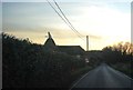
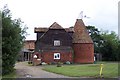
5
Rushbourne Oast, Hoath Road, Hoath, Kent
Single square kiln oast house.
Image: © Oast House Archive
Taken: 17 Apr 2009
0.09 miles
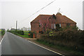
7
Oast House near Sturry, Kent
Oast house at Buckwell, near Sturry, Kent. Unlike most these days, this one remains in near original condition, unspoiled by conversion to residential use.
Image: © Ron Strutt
Taken: 2 Jul 2004
0.14 miles