IMAGES TAKEN NEAR TO
Maple Court, CANTERBURY, CT3 4JF
Introduction
This page details the photographs taken nearby to Maple Court, CT3 4JF by members of the Geograph project.
The Geograph project started in 2005 with the aim of publishing, organising and preserving representative images for every square kilometre of Great Britain, Ireland and the Isle of Man.

There are currently over 7.5m images from over14,400 individuals and you can help contribute to the project by visiting https://www.geograph.org.uk
Image Map
Images are licensed for reuse under creativecommons.org/licenses/by-sa/2.0
Notes
- Clicking on the map will re-center to the selected point.
- The higher the marker number, the further away the image location is from the centre of the postcode.
Image Listing (43 Images Found)
Images are licensed for reuse under creativecommons.org/licenses/by-sa/2.0
Image
Details
Distance
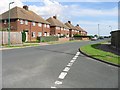
1
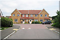
Houses on The Avenue
A terrace of three houses at junction with Larch Close (to right).
Image: © Oast House Archive
Taken: 24 Jun 2010
0.05 miles
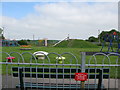
3
Children?s playground
The track, on the right, takes one to Joiner’s Farm.
Image: © John Baker
Taken: 18 Sep 2014
0.06 miles
5
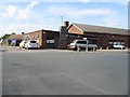
Chislet Colliery Welfare Club, Hersden
The club has been in existence since the late 1950's and had been built to support the then local mining community and the village. The Club,is still successfully run even since the demise of the mines in Kent.
Image: © Nick Smith
Taken: 7 Jul 2007
0.08 miles
6
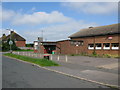
Chislet Colliery Welfare Club on The Avenue, Hersden
Image: © Nick Smith
Taken: 2 Jun 2010
0.08 miles
7
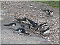
House Martins gathering mud from the edge of the road
Image: © Nick Smith
Taken: 2 Jun 2010
0.08 miles
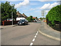
8
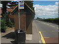
Bus Shelter on the A28
On Island Road, near Larch Close.
Image: © David Anstiss
Taken: 11 Jul 2010
0.09 miles
9
View along The Sycamores towards Island Road
Image: © Nick Smith
Taken: 7 Jul 2007
0.09 miles
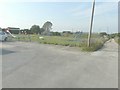
10
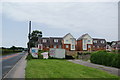
New housing development on the edge of Hersden
Hersden is almost entirely residential with regular buses into Canterbury along the A28, which is on the left side of this view.
Image: © Bill Boaden
Taken: 28 Jun 2012
0.10 miles