IMAGES TAKEN NEAR TO
School Lane, CANTERBURY, CT3 4FW
Introduction
This page details the photographs taken nearby to School Lane, CT3 4FW by members of the Geograph project.
The Geograph project started in 2005 with the aim of publishing, organising and preserving representative images for every square kilometre of Great Britain, Ireland and the Isle of Man.

There are currently over 7.5m images from over14,400 individuals and you can help contribute to the project by visiting https://www.geograph.org.uk
Image Map
Images are licensed for reuse under creativecommons.org/licenses/by-sa/2.0
Notes
- Clicking on the map will re-center to the selected point.
- The higher the marker number, the further away the image location is from the centre of the postcode.
Image Listing (55 Images Found)
Images are licensed for reuse under creativecommons.org/licenses/by-sa/2.0
Image
Details
Distance
7
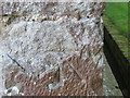
Ordnance Survey Cut Mark
This somewhat damaged mark can be found on the wall of Holy Cross Church in Hoath.
For more detail see : http://www.bench-marks.org.uk/bm75222
Image: © Peter Wood
Taken: 16 Feb 2016
0.04 miles
8
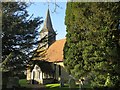
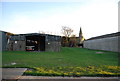
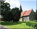
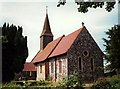
The Entrance Porch and Spire of Holy Cross Church in Hoath
Viewed from the south. The Spire was also used as an Intersected Station by the Ordnance Survey. http://trigpointing.uk/trig/25473
Image: © Peter Wood
Taken: 16 Feb 2016
0.04 miles