IMAGES TAKEN NEAR TO
Kingfisher Close, CANTERBURY, CT3 4EW
Introduction
This page details the photographs taken nearby to Kingfisher Close, CT3 4EW by members of the Geograph project.
The Geograph project started in 2005 with the aim of publishing, organising and preserving representative images for every square kilometre of Great Britain, Ireland and the Isle of Man.

There are currently over 7.5m images from over14,400 individuals and you can help contribute to the project by visiting https://www.geograph.org.uk
Image Map
Images are licensed for reuse under creativecommons.org/licenses/by-sa/2.0
Notes
- Clicking on the map will re-center to the selected point.
- The higher the marker number, the further away the image location is from the centre of the postcode.
Image Listing (24 Images Found)
Images are licensed for reuse under creativecommons.org/licenses/by-sa/2.0
Image
Details
Distance
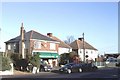
1
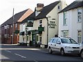
Motech Motor Company
Secondhand car sales and repairs on Island Road.
Image: © Oast House Archive
Taken: 24 Jun 2010
0.02 miles
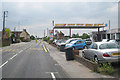
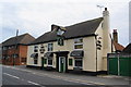
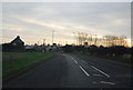
3
Garage in Upstreet
As with many other similar establishments, this was once a petrol filling station which proved uneconomic.
Image: © Bill Boaden
Taken: 28 Jun 2012
0.05 miles
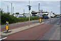
9
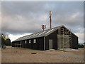
Barn and mobile phone towers near Port Farm
Newly built barn on an access road to the farm from Island Road.
Image: © David Anstiss
Taken: 24 Oct 2010
0.13 miles