IMAGES TAKEN NEAR TO
North Stream, CANTERBURY, CT3 4EQ
Introduction
This page details the photographs taken nearby to North Stream, CT3 4EQ by members of the Geograph project.
The Geograph project started in 2005 with the aim of publishing, organising and preserving representative images for every square kilometre of Great Britain, Ireland and the Isle of Man.

There are currently over 7.5m images from over14,400 individuals and you can help contribute to the project by visiting https://www.geograph.org.uk
Image Map
Images are licensed for reuse under creativecommons.org/licenses/by-sa/2.0
Notes
- Clicking on the map will re-center to the selected point.
- The higher the marker number, the further away the image location is from the centre of the postcode.
Image Listing (23 Images Found)
Images are licensed for reuse under creativecommons.org/licenses/by-sa/2.0
Image
Details
Distance
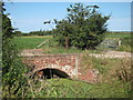
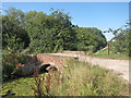
1
Looking S along North Stream
From the bridge which forms the beginning of Snake Drove
Image: © Nick Smith
Taken: 7 Jul 2007
0.08 miles
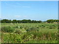
2
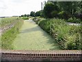
Looking N along the North Stream
The North Stream was almost totally covered in weed with just a small area of open water near the bridge, the route of the Wantsum Walk.
Image: © Nick Smith
Taken: 7 Jul 2007
0.08 miles
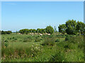
8
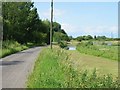
Sheep grazing, Marshside
There seems to be a lot of what looks like Spear Thistle in the field.
Image: © Robin Webster
Taken: 4 Jun 2015
0.12 miles
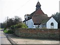
10
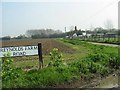
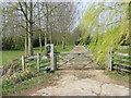
The chapel of Chapel Lane and Reynolds Farm Road
Image: © Nick Smith
Taken: 31 Mar 2007
0.12 miles