IMAGES TAKEN NEAR TO
North Stream, CANTERBURY, CT3 4EL
Introduction
This page details the photographs taken nearby to North Stream, CT3 4EL by members of the Geograph project.
The Geograph project started in 2005 with the aim of publishing, organising and preserving representative images for every square kilometre of Great Britain, Ireland and the Isle of Man.

There are currently over 7.5m images from over14,400 individuals and you can help contribute to the project by visiting https://www.geograph.org.uk
Image Map
Images are licensed for reuse under creativecommons.org/licenses/by-sa/2.0
Notes
- Clicking on the map will re-center to the selected point.
- The higher the marker number, the further away the image location is from the centre of the postcode.
Image Listing (21 Images Found)
Images are licensed for reuse under creativecommons.org/licenses/by-sa/2.0
Image
Details
Distance
3
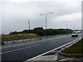
A299 Thanet Way
Looking towards Whitstable, see where we were 6 minutes later in this picture, Image
Image: © Phillip Perry
Taken: 23 Sep 2008
0.09 miles
5
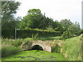
North Stream bridge near Little Grays
This farm bridge is used by a footpath, which heads from the lane near Little Grays Farm right towards the A299 Thanet Way.
Image: © David Anstiss
Taken: 30 May 2011
0.11 miles
6
Brook Lane approaching Thanet Way, near Marshside
Image: © Chris Whippet
Taken: 11 Jul 2010
0.11 miles
7
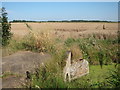
Bridge and field by North Stream
By the Wantsum Walk.
Image: © Oast House Archive
Taken: 18 Aug 2012
0.11 miles
8
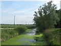
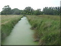
North Stream towards Marshside
This stream leads beside a lane from Little Greys Farm towards Boyden Gate.
The Chislets Marshes are on the left.
Image: © David Anstiss
Taken: 30 May 2011
0.12 miles
9
Marsh Drain towards North Stream
As seen from Image
This field drain flows through the Chislet Marshes towards a stream running beside the lane near Little Greys Farm.
Image: © David Anstiss
Taken: 30 May 2011
0.12 miles
10
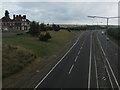
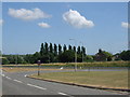
A299 towards St. Nicholas at Wade
As seen from the road bridge near the Roman Galley.
This dual carriageway leads from the M2 near Faversham towards Ramsgate.
The Roman Galley (on the left) is a converted pub, now a block of apartments.
Image: © David Anstiss
Taken: 8 Aug 2010
0.13 miles