IMAGES TAKEN NEAR TO
Forge Lane, CANTERBURY, CT3 4EF
Introduction
This page details the photographs taken nearby to Forge Lane, CT3 4EF by members of the Geograph project.
The Geograph project started in 2005 with the aim of publishing, organising and preserving representative images for every square kilometre of Great Britain, Ireland and the Isle of Man.

There are currently over 7.5m images from over14,400 individuals and you can help contribute to the project by visiting https://www.geograph.org.uk
Image Map
Images are licensed for reuse under creativecommons.org/licenses/by-sa/2.0
Notes
- Clicking on the map will re-center to the selected point.
- The higher the marker number, the further away the image location is from the centre of the postcode.
Image Listing (52 Images Found)
Images are licensed for reuse under creativecommons.org/licenses/by-sa/2.0
Image
Details
Distance
1
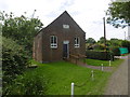
Wesleyan Chapel, Boyden Gate
The date above the door is 1841. It is seen from Chapel Lane.
Image: © Marathon
Taken: 7 Jul 2016
0.03 miles
4
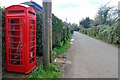
K6 telephone box under renovation, North Stream
Image: © Oast House Archive
Taken: 4 Apr 2019
0.07 miles
5
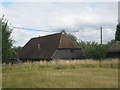
Marshside Farmhouse Barn
Converted barn in the farm near Boyden Gate.
Seen from the footpath behind the farm.
Image: © David Anstiss
Taken: 8 Aug 2010
0.09 miles
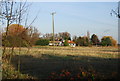
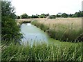
7
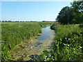
North Stream, Marshside
Looking upstream, with little flow in June.
Image: © Robin Webster
Taken: 4 Jun 2015
0.11 miles
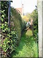
8
Stile on Saxon Shore Way near Boyden Gate
The long distance path leads toward the village near the Chislet Marshes.
Image: © David Anstiss
Taken: 8 Aug 2010
0.11 miles
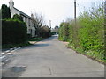
9
Looking N to Boyden Gate from Chitty Lane
Image: © Nick Smith
Taken: 7 Jul 2007
0.12 miles