IMAGES TAKEN NEAR TO
Boyden Gate Hill, CANTERBURY, CT3 4ED
Introduction
This page details the photographs taken nearby to Boyden Gate Hill, CT3 4ED by members of the Geograph project.
The Geograph project started in 2005 with the aim of publishing, organising and preserving representative images for every square kilometre of Great Britain, Ireland and the Isle of Man.

There are currently over 7.5m images from over14,400 individuals and you can help contribute to the project by visiting https://www.geograph.org.uk
Image Map
Images are licensed for reuse under creativecommons.org/licenses/by-sa/2.0
Notes
- Clicking on the map will re-center to the selected point.
- The higher the marker number, the further away the image location is from the centre of the postcode.
Image Listing (31 Images Found)
Images are licensed for reuse under creativecommons.org/licenses/by-sa/2.0
Image
Details
Distance
1
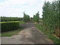
Byway near Boyden Gate
This track through a large orchards leads from Boyden Gate Hill towards Reynolds Farm Lane.
Image: © David Anstiss
Taken: 8 Aug 2010
0.01 miles
3
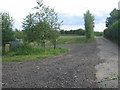
Footpath junction on the byway near Midway Farm
The Saxon Shore Way turns left from a byway from Reynolds Farm Lane, down a footpath leading towards Boyden Gate. The byway carries on towards Boyden Gate Hill.
Image: © David Anstiss
Taken: 8 Aug 2010
0.04 miles
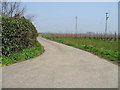
6
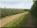
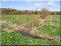
Saxon Shore Way towards Boyden Gate
The long distance path heads towards the village near the Chislet Marshes.
Image: © David Anstiss
Taken: 8 Aug 2010
0.09 miles
7
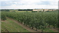
View of an orchard near Boyden Gate Hill
Looking south-westerly across the orchard beside the road.
Shelving Wood is in the background.
Image: © David Anstiss
Taken: 8 Aug 2010
0.12 miles
8
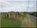
Pillbox beside Boyden Gate Hill
Old World War 2 defensive position above the Chislet Marshes.
Mansfield Farm is in the background.
Image: © David Anstiss
Taken: 8 Aug 2010
0.15 miles
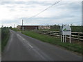
10
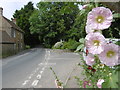
Boyden Gate Hill
This is the main road junction in Boyden Gate. Boyden Gate Hill ahead leads to Highstead while the road to the right leads to Marshside.
Image: © Marathon
Taken: 7 Jul 2016
0.17 miles