IMAGES TAKEN NEAR TO
Chislet Forstal, CANTERBURY, CT3 4DT
Introduction
This page details the photographs taken nearby to Chislet Forstal, CT3 4DT by members of the Geograph project.
The Geograph project started in 2005 with the aim of publishing, organising and preserving representative images for every square kilometre of Great Britain, Ireland and the Isle of Man.

There are currently over 7.5m images from over14,400 individuals and you can help contribute to the project by visiting https://www.geograph.org.uk
Image Map
Images are licensed for reuse under creativecommons.org/licenses/by-sa/2.0
Notes
- Clicking on the map will re-center to the selected point.
- The higher the marker number, the further away the image location is from the centre of the postcode.
Image Listing (33 Images Found)
Images are licensed for reuse under creativecommons.org/licenses/by-sa/2.0
Image
Details
Distance
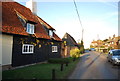
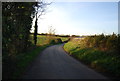
2
Hollow Street
Part of the parish of Chislet.
Image: © N Chadwick
Taken: 10 Dec 2011
0.03 miles
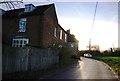
4
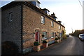
Hollow Street Cottages
Grade II listed. http://www.britishlistedbuildings.co.uk/en-171126-hollow-street-cottages-1-4-chislet
Image: © N Chadwick
Taken: 10 Dec 2011
0.06 miles
5
Hollow Street
Heading to Chislet Forstal.
Image: © N Chadwick
Taken: 10 Dec 2011
0.07 miles
7
Hollow Street
Part of the parish of Chislet.
Image: © N Chadwick
Taken: 10 Dec 2011
0.07 miles
8
Hollow Street House
Hollow Street is in the Parish of Chislet.
Image: © N Chadwick
Taken: 10 Dec 2011
0.08 miles
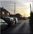
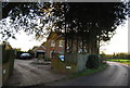
9
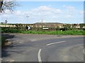
Junction of Hollow Street, Church Lane and Sandpit Hill
Image: © Nick Smith
Taken: 18 Mar 2007
0.10 miles
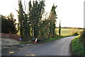
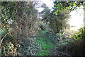
10
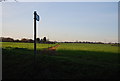
Footpath across the fields
The path goes off Hollow Street.
Image: © N Chadwick
Taken: 10 Dec 2011
0.10 miles