IMAGES TAKEN NEAR TO
Grove, CANTERBURY, CT3 4BJ
Introduction
This page details the photographs taken nearby to CT3 4BJ by members of the Geograph project.
The Geograph project started in 2005 with the aim of publishing, organising and preserving representative images for every square kilometre of Great Britain, Ireland and the Isle of Man.

There are currently over 7.5m images from over14,400 individuals and you can help contribute to the project by visiting https://www.geograph.org.uk
Image Map
Images are licensed for reuse under creativecommons.org/licenses/by-sa/2.0
Notes
- Clicking on the map will re-center to the selected point.
- The higher the marker number, the further away the image location is from the centre of the postcode.
Image Listing (9 Images Found)
Images are licensed for reuse under creativecommons.org/licenses/by-sa/2.0
Image
Details
Distance
1
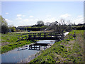
A bridge over a drainage dyke, Stodmarsh Nature Reserve
Image: © david mills
Taken: 15 Apr 2008
0.06 miles
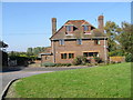
2
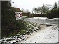
Continuation of farm track to Newborns Farm from Undertrees Farm.
Image: © Nick Smith
Taken: 21 Jan 2007
0.06 miles
4
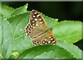
Speckled wood butterfly in Stodmarsh National Nature Reserve
Image: © pam fray
Taken: 1 Aug 2017
0.12 miles
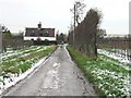
5
Junction of Newborn Farm Road with Grove Road
Image: © Nick Smith
Taken: 8 Feb 2007
0.20 miles

7
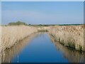
Stodmarsh National Nature Reserve
View from the footpath of one of the drainage ditches through the reedbeds.
Image: © pam fray
Taken: 21 Apr 2022
0.24 miles
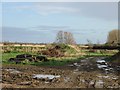
8
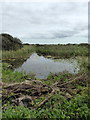
A ditch at Stodmarsh National Nature Reserve
The many ditches and drains on the reserve allow movement of water and control the water levels to stop them drying up. They are cleared periodically to prevent them from becoming dominated by reeds or scrub.
Image: © pam fray
Taken: 28 Aug 2018
0.24 miles