IMAGES TAKEN NEAR TO
Swanton Lane, CANTERBURY, CT3 4AX
Introduction
This page details the photographs taken nearby to Swanton Lane, CT3 4AX by members of the Geograph project.
The Geograph project started in 2005 with the aim of publishing, organising and preserving representative images for every square kilometre of Great Britain, Ireland and the Isle of Man.

There are currently over 7.5m images from over14,400 individuals and you can help contribute to the project by visiting https://www.geograph.org.uk
Image Map
Images are licensed for reuse under creativecommons.org/licenses/by-sa/2.0
Notes
- Clicking on the map will re-center to the selected point.
- The higher the marker number, the further away the image location is from the centre of the postcode.
Image Listing (9 Images Found)
Images are licensed for reuse under creativecommons.org/licenses/by-sa/2.0
Image
Details
Distance
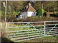
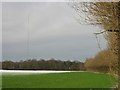
2
Swanton Farm cottages, looking NE from Swanton Lane
Image: © Nick Smith
Taken: 8 Feb 2007
0.02 miles
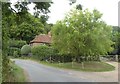
4
Bend in Swanton Lane near Swanton Farm Cottages
Image: © Nick Smith
Taken: 8 Feb 2007
0.06 miles
6
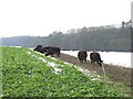
Cows on Shepherd's Bank
The cows were reaching under the electric fence to graze on the new green crop.
Image: © Nick Smith
Taken: 8 Feb 2007
0.23 miles
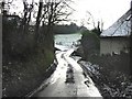
7

Crossroads of Swanton Lane and Court Hill
Image: © Nick Smith
Taken: 8 Feb 2007
0.24 miles
8
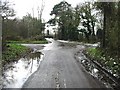
Crossroads
Looking along Hollybush Road running into Swanton Lane, crossed by Court Hill.
Image: © Nick Smith
Taken: 8 Feb 2007
0.24 miles
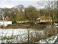
9
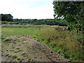
Field off Swanton Lane
Trenleypark Wood in distance.
Image: © Oast House Archive
Taken: 1 Sep 2010
0.24 miles