IMAGES TAKEN NEAR TO
Stodmarsh Road, CANTERBURY, CT3 4AG
Introduction
This page details the photographs taken nearby to Stodmarsh Road, CT3 4AG by members of the Geograph project.
The Geograph project started in 2005 with the aim of publishing, organising and preserving representative images for every square kilometre of Great Britain, Ireland and the Isle of Man.

There are currently over 7.5m images from over14,400 individuals and you can help contribute to the project by visiting https://www.geograph.org.uk
Image Map
Images are licensed for reuse under creativecommons.org/licenses/by-sa/2.0
Notes
- Clicking on the map will re-center to the selected point.
- The higher the marker number, the further away the image location is from the centre of the postcode.
Image Listing (30 Images Found)
Images are licensed for reuse under creativecommons.org/licenses/by-sa/2.0
Image
Details
Distance
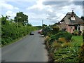
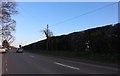
2
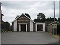
Littlebourne Seventh Day Adventist Church
On Stodmarsh Road.
Image: © David Anstiss
Taken: 15 Aug 2010
0.08 miles
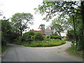
4
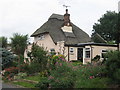
Lords Well Cottage
Thatched Cottage on Stodmarsh Road.
Image: © David Anstiss
Taken: 15 Aug 2010
0.10 miles
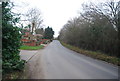
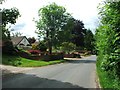
7
Junction of The Mount
New development off Stodmarsh Road.
Image: © Oast House Archive
Taken: 24 Jun 2010
0.11 miles