IMAGES TAKEN NEAR TO
Bossington, CANTERBURY, CT3 3LN
Introduction
This page details the photographs taken nearby to Bossington, CT3 3LN by members of the Geograph project.
The Geograph project started in 2005 with the aim of publishing, organising and preserving representative images for every square kilometre of Great Britain, Ireland and the Isle of Man.

There are currently over 7.5m images from over14,400 individuals and you can help contribute to the project by visiting https://www.geograph.org.uk
Image Map
Images are licensed for reuse under creativecommons.org/licenses/by-sa/2.0
Notes
- Clicking on the map will re-center to the selected point.
- The higher the marker number, the further away the image location is from the centre of the postcode.
Image Listing (14 Images Found)
Images are licensed for reuse under creativecommons.org/licenses/by-sa/2.0
Image
Details
Distance
1

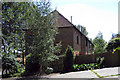
The Rectory, Bossington Farm
On Bossington Road.
Image: © David Anstiss
Taken: 15 Aug 2010
0.02 miles
3
Bossington Oast, Bossington, Adisham, Kent
Kilns now gone, but probably would have been around five to the rear of the building.
Image: © Oast House Archive
Taken: 4 Jul 2009
0.09 miles
4

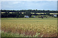
Bossington Granary
Part of Bossington Farm. The furthest house is called Bossington Oast.
Image: © David Anstiss
Taken: 15 Aug 2010
0.10 miles
5
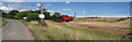
Combine Harvester at Bossington Farm
Image: © Oast House Archive
Taken: 22 Jul 2010
0.11 miles
6

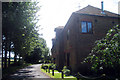
The Barn, Bossington
Converted farm barn, part of Bossington Farm on Bossington Road.
Image: © David Anstiss
Taken: 15 Aug 2010
0.13 miles
9
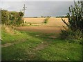
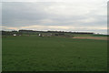
View across the fields from Bossington Farm
Image: © Nick Smith
Taken: 26 Sep 2007
0.13 miles
10

Little Bossington Farm House
Part of Bossington Farm on Bossington Road.
Image: © David Anstiss
Taken: 15 Aug 2010
0.14 miles