IMAGES TAKEN NEAR TO
Woodlands Road, CANTERBURY, CT3 3LG
Introduction
This page details the photographs taken nearby to Woodlands Road, CT3 3LG by members of the Geograph project.
The Geograph project started in 2005 with the aim of publishing, organising and preserving representative images for every square kilometre of Great Britain, Ireland and the Isle of Man.

There are currently over 7.5m images from over14,400 individuals and you can help contribute to the project by visiting https://www.geograph.org.uk
Image Map
Images are licensed for reuse under creativecommons.org/licenses/by-sa/2.0
Notes
- Clicking on the map will re-center to the selected point.
- The higher the marker number, the further away the image location is from the centre of the postcode.
Image Listing (5 Images Found)
Images are licensed for reuse under creativecommons.org/licenses/by-sa/2.0
Image
Details
Distance
1
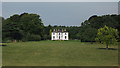
Woodlands Manor
As seen from the bridleway between Woodlands Road and Ileden Farm.
Image: © David Anstiss
Taken: 5 Sep 2010
0.03 miles
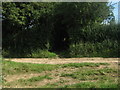
2
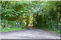
Start of public byway towards Aylesham
Image: © Robin Webster
Taken: 2 Sep 2017
0.11 miles
3
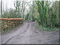
Selection of muddy tracks, looking SE from sharp bend, Woodlands Road
Image: © Nick Smith
Taken: 4 Feb 2007
0.12 miles
4
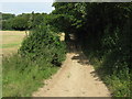
Byway to Woodlands Road
This track leads from Woodlands Wood towards the road near Woodlands Manor.
As seen from Image
Image: © David Anstiss
Taken: 5 Sep 2010
0.23 miles
5
Bridleway crosses a byway near Woodlands Manor
A bridleway track leads from Ileden Farm straight on towards Oxenden Wood and Woodlands Road near Adisham. Another track (byway) leads left towards Woodlands Road near Woodlands Manor, it also leads right through Woodlands Wood.
Image: © David Anstiss
Taken: 5 Sep 2010
0.24 miles