IMAGES TAKEN NEAR TO
The Street, CANTERBURY, CT3 3LB
Introduction
This page details the photographs taken nearby to The Street, CT3 3LB by members of the Geograph project.
The Geograph project started in 2005 with the aim of publishing, organising and preserving representative images for every square kilometre of Great Britain, Ireland and the Isle of Man.

There are currently over 7.5m images from over14,400 individuals and you can help contribute to the project by visiting https://www.geograph.org.uk
Image Map
Images are licensed for reuse under creativecommons.org/licenses/by-sa/2.0
Notes
- Clicking on the map will re-center to the selected point.
- The higher the marker number, the further away the image location is from the centre of the postcode.
Image Listing (33 Images Found)
Images are licensed for reuse under creativecommons.org/licenses/by-sa/2.0
Image
Details
Distance
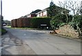
2
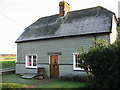
The Old Off Licence, The Street, Adisham
Image: © Nick Smith
Taken: 29 Dec 2008
0.04 miles
7
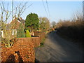
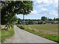
Woodlands Road Adisham
Looking NE towards Adisham village.
Image: © Nick Smith
Taken: 13 May 2006
0.08 miles
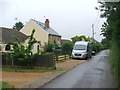
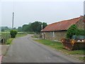
8
View along Woodlands Road towards Adisham.
Image: © Nick Smith
Taken: 28 Jan 2007
0.08 miles
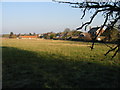
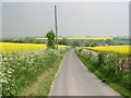
9
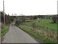
Woodlands Road approaches Adisham
The scaffolding ahead is not actually in the middle of the road, which kinks to the right.
Image: © Robin Webster
Taken: 2 Sep 2017
0.09 miles
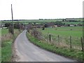
10
View along Woodlands Road towards Adisham.
Image: © Nick Smith
Taken: 28 Jan 2007
0.10 miles