IMAGES TAKEN NEAR TO
Adisham Road, CANTERBURY, CT3 3JB
Introduction
This page details the photographs taken nearby to Adisham Road, CT3 3JB by members of the Geograph project.
The Geograph project started in 2005 with the aim of publishing, organising and preserving representative images for every square kilometre of Great Britain, Ireland and the Isle of Man.

There are currently over 7.5m images from over14,400 individuals and you can help contribute to the project by visiting https://www.geograph.org.uk
Image Map
Images are licensed for reuse under creativecommons.org/licenses/by-sa/2.0
Notes
- Clicking on the map will re-center to the selected point.
- The higher the marker number, the further away the image location is from the centre of the postcode.
Image Listing (4 Images Found)
Images are licensed for reuse under creativecommons.org/licenses/by-sa/2.0
Image
Details
Distance
1
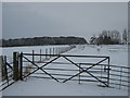
Gate near Uffington Court
This farm gate leads from a large field towards a track to the farm.
It is also used by a footpath from the B2046 Adisham Road, leading past the Waterworks and then the farm before heading towards Love Lane.
Fitzwalter Wood is in the background.
Image: © David Anstiss
Taken: 19 Dec 2010
0.17 miles
2
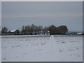
Footpath to Waterworks
A footpath from Love Lane leads past Uffington Court and farm and onwards to the Waterworks on B2046 Adisham Road.
Image: © David Anstiss
Taken: 19 Dec 2010
0.18 miles
3
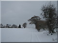
Track near Uffington Court
A track leads from a large field towards the farm buildings.
A footpath leads from Love Lane, leads along the track and then past the farm towards the Waterworks on the B2046 Adisham Road.
Image: © David Anstiss
Taken: 19 Dec 2010
0.18 miles
4
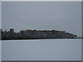
Fitzwalter Wood
As seen from a footpath near Uffington Court.
Image: © David Anstiss
Taken: 19 Dec 2010
0.21 miles