IMAGES TAKEN NEAR TO
Ratling Road, CANTERBURY, CT3 3HL
Introduction
This page details the photographs taken nearby to Ratling Road, CT3 3HL by members of the Geograph project.
The Geograph project started in 2005 with the aim of publishing, organising and preserving representative images for every square kilometre of Great Britain, Ireland and the Isle of Man.

There are currently over 7.5m images from over14,400 individuals and you can help contribute to the project by visiting https://www.geograph.org.uk
Image Map
Images are licensed for reuse under creativecommons.org/licenses/by-sa/2.0
Notes
- Clicking on the map will re-center to the selected point.
- The higher the marker number, the further away the image location is from the centre of the postcode.
Image Listing (29 Images Found)
Images are licensed for reuse under creativecommons.org/licenses/by-sa/2.0
Image
Details
Distance
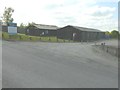
2
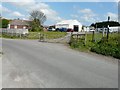
Corby Farm, Ratling Road
It is marked on the map as being a poultry farm.
Image: © John Baker
Taken: 19 Apr 2014
0.05 miles
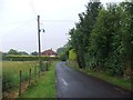
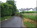
4
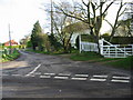
Junction of minor road with Ratling Road.
Image: © Nick Smith
Taken: 14 Jan 2007
0.06 miles
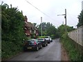
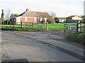
5
Ratling Farm
Ratling Farm is in the centre of the hamlet of Ratling. Ratling is still just separate from the much larger Aylesham.
Image: © Marathon
Taken: 10 Jul 2015
0.07 miles
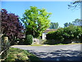
7
Sprockets, Ratling Road
The board on the left gives details of this business, which offers performance bike sales, components, repairs and service and clothing and accessories.
Image: © John Baker
Taken: 19 Apr 2014
0.08 miles