IMAGES TAKEN NEAR TO
Coalfield Grove, CANTERBURY, CT3 3FX
Introduction
This page details the photographs taken nearby to Coalfield Grove, CT3 3FX by members of the Geograph project.
The Geograph project started in 2005 with the aim of publishing, organising and preserving representative images for every square kilometre of Great Britain, Ireland and the Isle of Man.

There are currently over 7.5m images from over14,400 individuals and you can help contribute to the project by visiting https://www.geograph.org.uk
Image Map
Images are licensed for reuse under creativecommons.org/licenses/by-sa/2.0
Notes
- Clicking on the map will re-center to the selected point.
- The higher the marker number, the further away the image location is from the centre of the postcode.
Image Listing (235 Images Found)
Images are licensed for reuse under creativecommons.org/licenses/by-sa/2.0
Image
Details
Distance
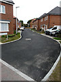
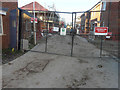
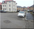
1
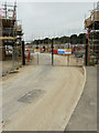
Millyard Road
The gate across the road is visible at the far end of the road in this image of Image The development is part of the Aylesham Garden Village project http://www.ayleshamgardenvillage.co.uk/
Image: © John Baker
Taken: 10 Jun 2018
0.02 miles
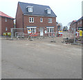
2
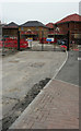
Millyard Road
This image of Image shows these houses, when they had been completed. The road is part of the Aylesham Garden Village project http://www.ayleshamgardenvillage.co.uk/
Image: © John Baker
Taken: 12 Aug 2018
0.03 miles
3
Millyard Road
This image of Image shows these houses, when they were being built. A road nameplate has since been erected for Canary Grove, which is the next road on the right. The development is part of the Aylesham Garden Village project http://www.ayleshamgardenvillage.co.uk/
Image: © John Baker
Taken: 11 Nov 2018
0.04 miles
4
Ropeway Drive
This view of Image was taken in January 2019 but work is still ongoing at the far end of the road. The development is part of the Aylesham Garden Village project http://www.ayleshamgardenvillage.co.uk/
Image: © John Baker
Taken: 17 Feb 2019
0.05 miles
5
Ropeway Drive
This was Image in February 2019. The development is part of the Aylesham Garden Village project http://www.ayleshamgardenvillage.co.uk/
Image: © John Baker
Taken: 1 Sep 2019
0.05 miles
6
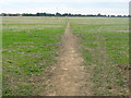
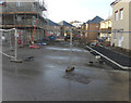
Footpath to Aylesham football pitch
This path leads from the Ratling footpath, through the empty field towards the football pitch on Dorman Avenue North.
It passes through planned development land.
Image: © David Anstiss
Taken: 5 Sep 2010
0.05 miles
7
Ropeway Drive
The development is part of the Aylesham Garden Village project http://www.ayleshamgardenvillage.co.uk/
Image: © John Baker
Taken: 18 Nov 2018
0.05 miles
8
Ropeway Drive
This was Image in November 2018. The development is part of the Aylesham Garden Village project http://www.ayleshamgardenvillage.co.uk/
Image: © John Baker
Taken: 6 Jan 2019
0.05 miles
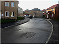
9
Coalfield Grove
The cream-coloured house, on the right, is the same as in this image of Image The development is part of the Aylesham Garden Village project http://www.ayleshamgardenvillage.co.uk/
Image: © John Baker
Taken: 11 Nov 2018
0.05 miles
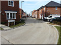
10
Coalfield Grove
An almost identical view of Image except that some of the houses had yet to be completed. The development is part of the Aylesham Garden Village project http://www.ayleshamgardenvillage.co.uk/
Image: © John Baker
Taken: 6 Jan 2019
0.06 miles