IMAGES TAKEN NEAR TO
School Square, CANTERBURY, CT3 3FG
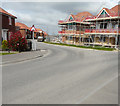
Introduction
This page details the photographs taken nearby to School Square, CT3 3FG by members of the Geograph project.
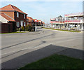
The Geograph project started in 2005 with the aim of publishing, organising and preserving representative images for every square kilometre of Great Britain, Ireland and the Isle of Man.

There are currently over 7.5m images from over14,400 individuals and you can help contribute to the project by visiting https://www.geograph.org.uk
Image Map
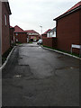
Images are licensed for reuse under creativecommons.org/licenses/by-sa/2.0
Notes
- Clicking on the map will re-center to the selected point.
- The higher the marker number, the further away the image location is from the centre of the postcode.
Image Listing (316 Images Found)
Images are licensed for reuse under creativecommons.org/licenses/by-sa/2.0
Image
Details
Distance
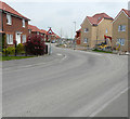
1
Harrison Road
A new road off Corminster Avenue, which is another new road off Derwent Way. The development is part of the Aylesham Garden Village project http://www.ayleshamgardenvillage.co.uk/
Image: © John Baker
Taken: 31 Jan 2016
0.02 miles
2
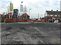
Looking northeast across Dorman Avenue North
Yellow notice-boards placed Image and Image warned that Dorman Avenue North would be closed from 3-17 August 2015, so that work could be carried out to lay a new surface along the road.
This view shows the new buildings, that are being erected as part of the Aylesham Garden Village development http://www.ayleshamgardenvillage.co.uk/ (whose website is updated daily) and part of a terrace, of older houses, across Derwent Way.
Image: © John Baker
Taken: 5 Aug 2015
0.03 miles
3
Looking NNW along Corminster Avenue
Compared with Image, the plastic sheeting, attached to the hoarding, has been removed which means that the storage area is now exposed. This is part of the Aylesham Garden Village project http://www.ayleshamgardenvillage.co.uk/
Image: © John Baker
Taken: 29 Jan 2017
0.03 miles
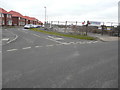
4
Junction of Corminster Avenue and Derwent Way
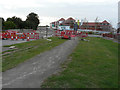
An area near to this junction was being used for Image but now it is gradually being turned over for housing. The development is part of the Aylesham Garden Village project http://www.ayleshamgardenvillage.co.uk/
Image: © John Baker
Taken: 21 Oct 2018
0.03 miles
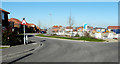
5
Junction of Corminster Avenue and Derwent Way
This was the Image in October 2018. The development is part of the Aylesham Garden Village project http://www.ayleshamgardenvillage.co.uk/
Image: © John Baker
Taken: 17 Feb 2019
0.03 miles
6
Looking west-northwest along Dorman Avenue North
Yellow notice-boards placed Image and Image warned that Dorman Avenue North would be closed from 3-17 August 2015, so that work could be carried out to lay a new surface along the road.
This view shows the new buildings, that are being erected as part of the Aylesham Garden Village development http://www.ayleshamgardenvillage.co.uk/ (whose website is updated daily). The red notice-board advises pedestrians to use the other footway.
Image: © John Baker
Taken: 5 Aug 2015
0.03 miles
7
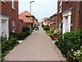
Chippers Way
The path is part of the Aylesham Garden Village project http://www.ayleshamgardenvillage.co.uk/
Image: © John Baker
Taken: 1 May 2019
0.03 miles
8
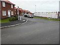
Corminster Avenue
Compared with Image, the road sign for Image is visible in the middle distance, where the white car was parked. Corminster Avenue is a new road off Derwent Way. The development is part of the Aylesham Garden Village project http://www.ayleshamgardenvillage.co.uk/
Image: © John Baker
Taken: 31 Jan 2016
0.03 miles
9
Junction of Corminster Avenue and Derwent Way
This was the Image in February 2019. The development is part of the Aylesham Garden Village project http://www.ayleshamgardenvillage.co.uk/
Image: © John Baker
Taken: 31 Mar 2019
0.03 miles
10
Junction of Corminster Avenue and Derwent Way
This was the Image in March 2019. The development is part of the Aylesham Garden Village project http://www.ayleshamgardenvillage.co.uk/
Image: © John Baker
Taken: 1 May 2019
0.03 miles