IMAGES TAKEN NEAR TO
Cripps Close, CANTERBURY, CT3 3BX
Introduction
This page details the photographs taken nearby to Cripps Close, CT3 3BX by members of the Geograph project.
The Geograph project started in 2005 with the aim of publishing, organising and preserving representative images for every square kilometre of Great Britain, Ireland and the Isle of Man.

There are currently over 7.5m images from over14,400 individuals and you can help contribute to the project by visiting https://www.geograph.org.uk
Image Map
Images are licensed for reuse under creativecommons.org/licenses/by-sa/2.0
Notes
- Clicking on the map will re-center to the selected point.
- The higher the marker number, the further away the image location is from the centre of the postcode.
Image Listing (181 Images Found)
Images are licensed for reuse under creativecommons.org/licenses/by-sa/2.0
Image
Details
Distance
1
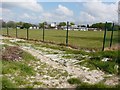
Aylesham Primary School
The school forms part of the Aylesham Garden Village project http://www.ayleshamgardenvillage.co.uk/
Image: © John Baker
Taken: 12 Aug 2018
0.06 miles
4
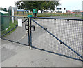
Aylesham Primary School
This is located in Attlee Avenue but here the view is from the northwest and shows the school through the perimeter fence. I assume that the former fence was constructed of chestnut-paling, as one is now lying on the ground.
Image: © John Baker
Taken: 19 Apr 2014
0.09 miles
5
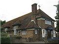
St Peter's Church, Aylesham
On Dorman Avenue North.
Designed very much like a house, except with the cross on the roof and ornate doorway.
Image: © David Anstiss
Taken: 5 Sep 2010
0.09 miles
6
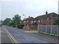
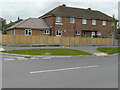
Looking WNW across Dorman Avenue North
Towards number 13, where alterations are taking place to the house. Planning permission has been granted by Dover District Council under application number DOV/16/00003 for “erection of a single storey side and rear extension (existing shed and side porch to be demolished)”. The property is also located on the corner of Attlee Avenue. This image shows Image after the alterations had been completed.
Image: © John Baker
Taken: 2 Oct 2016
0.10 miles
7
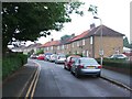
13, Dorman Avenue North
It is the house with the green front door, which can also be seen in the image of Image
Image: © John Baker
Taken: 8 Oct 2017
0.10 miles
8
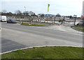
Looking south across Dorman Avenue North
From the entrance to Cordale Road towards the new teaching block, under construction, at Aylesham Primary School in Attlee Avenue. Planning permission has been granted by Dover District Council under application number DOV/16/00229 for the “construction of a two-storey teaching block containing new classrooms, associated staff, dining and welfare facilities and multi-purpose sports hall together with subsequent demolition of existing life-expired school buildings and reinstatement of land; formation of new pedestrian access to the school from Attlee Avenue; reconfiguration of external spaces to provide new and enhanced hard and soft play areas with associated landscaping, including formation of replacement ecology habitat area; extension of existing main school car park to provide one additional parking space; and other associated improvements”. The development is part of the Aylesham Garden Village project http://www.ayleshamgardenvillage.co.uk/
Image: © John Baker
Taken: 26 Mar 2017
0.10 miles
9
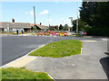
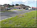
Closure of Dorman Avenue North
The road was in the process of being resurfaced, which had been scheduled to take place between 31 May and 10 July 2016. The diversion road sign points to Milner Crescent.
Image: © John Baker
Taken: 3 Jul 2016
0.11 miles
10
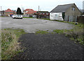
Carpark, Dorman Avenue North
It is free to park here.
Image: © John Baker
Taken: 31 Jan 2016
0.11 miles