IMAGES TAKEN NEAR TO
Milner Crescent, CANTERBURY, CT3 3BH
Introduction
This page details the photographs taken nearby to Milner Crescent, CT3 3BH by members of the Geograph project.
The Geograph project started in 2005 with the aim of publishing, organising and preserving representative images for every square kilometre of Great Britain, Ireland and the Isle of Man.

There are currently over 7.5m images from over14,400 individuals and you can help contribute to the project by visiting https://www.geograph.org.uk
Image Map
Images are licensed for reuse under creativecommons.org/licenses/by-sa/2.0
Notes
- Clicking on the map will re-center to the selected point.
- The higher the marker number, the further away the image location is from the centre of the postcode.
Image Listing (71 Images Found)
Images are licensed for reuse under creativecommons.org/licenses/by-sa/2.0
Image
Details
Distance
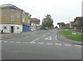
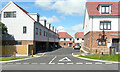
1
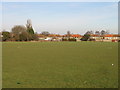
Houses on The Crescent, Aylesham, overlooking playing field
Image: © Nick Smith
Taken: 11 Jan 2009
0.03 miles
4
Progress of Snowdown Colliery Welfare Club
A description of the Dover District Council’s planning application can be found in this view of Image taken in September 2013.
Image: © John Baker
Taken: 19 Apr 2014
0.08 miles
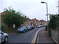
5
Dorman Avenue South
Seen from its junction with Market Place.
Image: © John Baker
Taken: 22 Sep 2013
0.09 miles
6
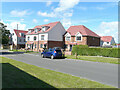
Greyhound Gardens
This row of semi-detached houses, located in Dorman Avenue South. are numbered from 13 to 17. Number 13 (the house at the far end) also appears in this view of Image
The location was a Image in September 2019.
Image: © John Baker
Taken: 4 Jul 2021
0.09 miles
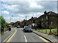
7

Snowdown Colliery Welfare Club, Spinney Lane
Planning permission has been granted by Dover District Council under application number DOV/09/00498 for the “erection of a detached building incorporating changing rooms, bars, offices and amenity rooms, construction of sports hall, netball and tennis courts, erection of flood lighting and alterations to existing vehicular access”.
Image: © John Baker
Taken: 22 Sep 2013
0.09 miles
8
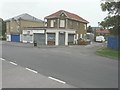
Buildings along Dorman Avenue South
From left to right: Market Fish Bar (with the blue roller blinds below the name), Just U (a shop stocking knitting wools) immediately next door to the fish bar; the other building appears to be derelict, as it has boarded up windows on the first floor.
Image: © John Baker
Taken: 22 Sep 2013
0.09 miles
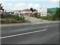
9
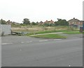
Derelict land beside Dorman Avenue South
Hoarding, that had been erected to hide this land, was mostly lying on the ground out of sight in this view, other than one panel on the left. The site used to be occupied by the Image
Image: © John Baker
Taken: 22 Sep 2013
0.09 miles
10
Greyhound Gardens
This close of semi-detached houses are numbered from 1 to 12.
Image: © John Baker
Taken: 4 Jul 2021
0.10 miles