IMAGES TAKEN NEAR TO
Burgess Road, CANTERBURY, CT3 3AU
Introduction
This page details the photographs taken nearby to Burgess Road, CT3 3AU by members of the Geograph project.
The Geograph project started in 2005 with the aim of publishing, organising and preserving representative images for every square kilometre of Great Britain, Ireland and the Isle of Man.

There are currently over 7.5m images from over14,400 individuals and you can help contribute to the project by visiting https://www.geograph.org.uk
Image Map
Images are licensed for reuse under creativecommons.org/licenses/by-sa/2.0
Notes
- Clicking on the map will re-center to the selected point.
- The higher the marker number, the further away the image location is from the centre of the postcode.
Image Listing (105 Images Found)
Images are licensed for reuse under creativecommons.org/licenses/by-sa/2.0
Image
Details
Distance
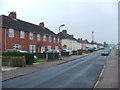
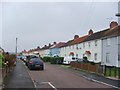
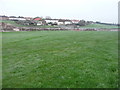
4
Houses on Burgess Road taken from Bell Grove
Image: © Nick Smith
Taken: 14 Jan 2007
0.07 miles
7
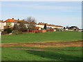
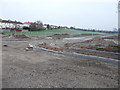
Looking east across Burgess Road
This view shows where the bus link road will run towards Aylesham railway station.
The http://www.ayleshamgardenvillage.co.uk/index.php/october-november-update/ gives the following information: Gallagher (Group Engineering) started works on the new bus link and street-lit pedestrian link on the field between Market Place and the rail station on 7th September. The road is scheduled for completion in May 2016 and works are progressing well. Burgess Road will be closed to traffic from 9th November until the early part of January, to raise the level of the junction.
Image: © John Baker
Taken: 13 Dec 2015
0.09 miles
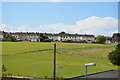
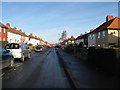
9
Looking northeast across Bell Grove
The road branching to the right is where a bus link road will run towards Aylesham railway station.
The http://www.ayleshamgardenvillage.co.uk/index.php/october-november-update/
gives the following information: Gallagher (Group Engineering) started works on the new bus link and street-lit pedestrian link on the field between Market Place and the rail station on 7th September. The road is scheduled for completion in May 2016 and works are progressing well. Burgess Road will be closed to traffic from 9th November until the early part of January, to raise the level of the junction.
Image: © John Baker
Taken: 13 Dec 2015
0.10 miles
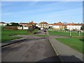
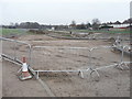
10
Looking north-northeast towards Burgess Road
The road under construction, running across the middle ground, is a bus link that will connect Market Square with Aylesham railway station. It is now known as Heritage Road.
The http://www.ayleshamgardenvillage.co.uk/index.php/october-november-update/
gives the following information: Gallagher (Group Engineering) started works on the new bus link and street-lit pedestrian link on the field between Market Place and the rail station on 7th September. The road is scheduled for completion in May 2016 and works are progressing well. Burgess Road will be closed to traffic from 9th November until the early part of January, to raise the level of the junction.
Image: © John Baker
Taken: 13 Dec 2015
0.10 miles