IMAGES TAKEN NEAR TO
Ware, CANTERBURY, CT3 2LX
Introduction
This page details the photographs taken nearby to Ware, CT3 2LX by members of the Geograph project.
The Geograph project started in 2005 with the aim of publishing, organising and preserving representative images for every square kilometre of Great Britain, Ireland and the Isle of Man.

There are currently over 7.5m images from over14,400 individuals and you can help contribute to the project by visiting https://www.geograph.org.uk
Image Map
Images are licensed for reuse under creativecommons.org/licenses/by-sa/2.0
Notes
- Clicking on the map will re-center to the selected point.
- The higher the marker number, the further away the image location is from the centre of the postcode.
Image Listing (35 Images Found)
Images are licensed for reuse under creativecommons.org/licenses/by-sa/2.0
Image
Details
Distance
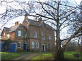
1
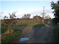
Footpath junction near Downfield Farm
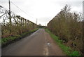
A footpath leads along a farm track from Knell Lane near Great Knell Farm, towards the lane to Ware. A footpath leads left along a track towards Great Ware Farm.
In the background is Ware Court.
Image: © David Anstiss
Taken: 16 Jan 2011
0.02 miles
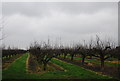
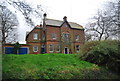
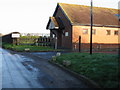
5
Ware Court
On lane junction near Wass Drove.
Image: © David Anstiss
Taken: 16 Jan 2011
0.10 miles
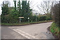
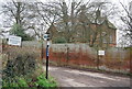
6
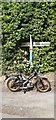
Direction Sign ? Signpost
Located on the northwest side of a crossroads on Wass Drove in Ash parish. 2 arms and no finial. See also https://www.geograph.org.uk/photo/3503229.
Milestone Society National ID: KE_TR2860
Image: © A Johns
Taken: Unknown
0.11 miles