IMAGES TAKEN NEAR TO
Westmarsh, CANTERBURY, CT3 2LW
Introduction
This page details the photographs taken nearby to CT3 2LW by members of the Geograph project.
The Geograph project started in 2005 with the aim of publishing, organising and preserving representative images for every square kilometre of Great Britain, Ireland and the Isle of Man.

There are currently over 7.5m images from over14,400 individuals and you can help contribute to the project by visiting https://www.geograph.org.uk
Image Map
Images are licensed for reuse under creativecommons.org/licenses/by-sa/2.0
Notes
- Clicking on the map will re-center to the selected point.
- The higher the marker number, the further away the image location is from the centre of the postcode.
Image Listing (37 Images Found)
Images are licensed for reuse under creativecommons.org/licenses/by-sa/2.0
Image
Details
Distance
2
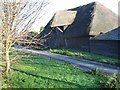
A Tudor Kentish barn
Described as one of the best examples of a Tudor Kentish barn in the district.
Image: © Nick Smith
Taken: 1 Jan 2008
0.04 miles
3
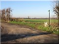
Looking NE along line of footpath near Westmarsh
Image: © Nick Smith
Taken: 12 Dec 2007
0.05 miles
4
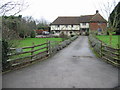
Wingham Barton Manor
A fine example of a medieval building.
Image: © Nick Smith
Taken: 1 Jan 2008
0.05 miles
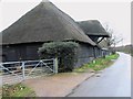
5
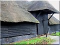
Detail on thatched barn near Wingham Barton Manor
Described on a local history board as "One of the best examples of a Tudor Kentish Barn in the district"
Image: © Nick Smith
Taken: 1 Jan 2008
0.05 miles
6
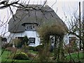
Idle Dyke Cottage
Idle Dyke Cottage. Possibly timber framed, rendered with thatched roof. One storey and attic with half-hipped roof, 1 raking dormer and stack to right. Central glazing bar sash with 2 wooden casements to right and ribbed door to left. Brick single storey extension to right with 1 wooden casement. http://www.imagesofengland.org.uk/details/default.aspx?pid=2&id=178130
Image: © Nick Smith
Taken: 1 Jan 2008
0.12 miles
7
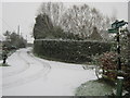
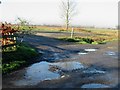
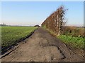
The Stour Valley Walk reaches Wass Drove
The long distance path leads along the lane in Westmarsh towards Paramour Street. Another footpath leads left (along Westmarsh Drove) towards the River Stour.
Image: © David Anstiss
Taken: 29 Nov 2010
0.15 miles
9
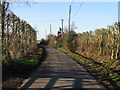
View along lane in Westmarsh
This lane forms part of the Stour Valley Walk
Image: © Nick Smith
Taken: 12 Dec 2007
0.17 miles