IMAGES TAKEN NEAR TO
Hoaden, CANTERBURY, CT3 2LQ
Introduction
This page details the photographs taken nearby to Hoaden, CT3 2LQ by members of the Geograph project.
The Geograph project started in 2005 with the aim of publishing, organising and preserving representative images for every square kilometre of Great Britain, Ireland and the Isle of Man.

There are currently over 7.5m images from over14,400 individuals and you can help contribute to the project by visiting https://www.geograph.org.uk
Image Map
Images are licensed for reuse under creativecommons.org/licenses/by-sa/2.0
Notes
- Clicking on the map will re-center to the selected point.
- The higher the marker number, the further away the image location is from the centre of the postcode.
Image Listing (12 Images Found)
Images are licensed for reuse under creativecommons.org/licenses/by-sa/2.0
Image
Details
Distance
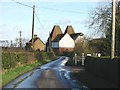
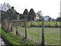
3
Hoaden Court Oast House
As seen from a footpath from Sheerwater Road towards Hoaden Lane.
Image: © David Anstiss
Taken: 29 Nov 2010
0.03 miles
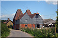
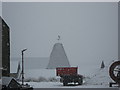
7
Fruit-pickers? caravans
To the left, of the caravans, is Hoaden Court in Image
Image: © John Baker
Taken: 7 Jun 2015
0.18 miles
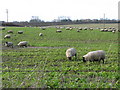
9
Footpath junction near Hoaden Farm
A footpath leads straight on from Hoaden Lane past Hoaden Court Farm towards Sheerwater Road. Another footpath heads right along the hedge towards Overland Farm, from Hoaden Farm.
Image: © David Anstiss
Taken: 29 Nov 2010
0.20 miles