IMAGES TAKEN NEAR TO
Nash, CANTERBURY, CT3 2JY
Introduction
This page details the photographs taken nearby to Nash, CT3 2JY by members of the Geograph project.
The Geograph project started in 2005 with the aim of publishing, organising and preserving representative images for every square kilometre of Great Britain, Ireland and the Isle of Man.

There are currently over 7.5m images from over14,400 individuals and you can help contribute to the project by visiting https://www.geograph.org.uk
Image Map
Images are licensed for reuse under creativecommons.org/licenses/by-sa/2.0
Notes
- Clicking on the map will re-center to the selected point.
- The higher the marker number, the further away the image location is from the centre of the postcode.
Image Listing (24 Images Found)
Images are licensed for reuse under creativecommons.org/licenses/by-sa/2.0
Image
Details
Distance
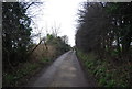
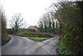
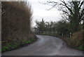
3
Road junction on Elmstone Road
Elmstone Road leads from Nash left towards Elmstone.
Hoaden Lane leads right to Hoaden.
Image: © David Anstiss
Taken: 29 Nov 2010
0.06 miles
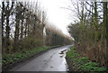
6
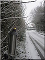
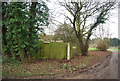
Hardy flame on Elmstone Road
This oil burner is one of many along Elmstone Road leading from Nash.
It is part of a wedding celebration at Nash Court Farm.
This was the only one still burning.
Image: © David Anstiss
Taken: 29 Nov 2010
0.08 miles