IMAGES TAKEN NEAR TO
Guilton, CANTERBURY, CT3 2HP
Introduction
This page details the photographs taken nearby to Guilton, CT3 2HP by members of the Geograph project.
The Geograph project started in 2005 with the aim of publishing, organising and preserving representative images for every square kilometre of Great Britain, Ireland and the Isle of Man.

There are currently over 7.5m images from over14,400 individuals and you can help contribute to the project by visiting https://www.geograph.org.uk
Image Map
Images are licensed for reuse under creativecommons.org/licenses/by-sa/2.0
Notes
- Clicking on the map will re-center to the selected point.
- The higher the marker number, the further away the image location is from the centre of the postcode.
Image Listing (41 Images Found)
Images are licensed for reuse under creativecommons.org/licenses/by-sa/2.0
Image
Details
Distance
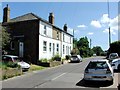
2
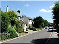
Guilton at the junction of Poulton Lane
The main road in Guilton is also called Guilton. Easy to remember at least.
Image: © David Howard
Taken: 22 Jun 2017
0.04 miles
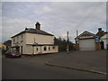
8
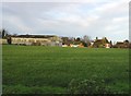
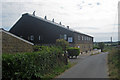
Approaching Guilton
An outlier of Ash. Seen are Guilton Farmhouse and Barn. The house is a grade II listed building, late 18th century.
Image: © Robin Webster
Taken: 29 Jun 2019
0.09 miles
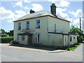
9
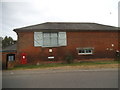
Highview Oast Nursing Home, Poulton Lane, Ash, Kent
Image: © Oast House Archive
Taken: 4 Jul 2009
0.10 miles
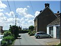
10
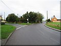
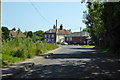
Junction of Guilton and Durlock Road, Ash
Image: © Nick Smith
Taken: 8 Jan 2007
0.11 miles