IMAGES TAKEN NEAR TO
Moat Lane, CANTERBURY, CT3 2DG
Introduction
This page details the photographs taken nearby to Moat Lane, CT3 2DG by members of the Geograph project.
The Geograph project started in 2005 with the aim of publishing, organising and preserving representative images for every square kilometre of Great Britain, Ireland and the Isle of Man.

There are currently over 7.5m images from over14,400 individuals and you can help contribute to the project by visiting https://www.geograph.org.uk
Image Map
Images are licensed for reuse under creativecommons.org/licenses/by-sa/2.0
Notes
- Clicking on the map will re-center to the selected point.
- The higher the marker number, the further away the image location is from the centre of the postcode.
Image Listing (95 Images Found)
Images are licensed for reuse under creativecommons.org/licenses/by-sa/2.0
Image
Details
Distance
1
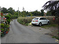
Development land, Moat Lane
Planning permission has been granted by Dover District Council under application number DOV/20/00330 for the “erection of a detached dwelling”.
A dwelling named Image was eventually built on the site.
Image: © John Baker
Taken: 14 Aug 2020
0.01 miles

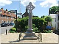
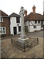
6
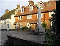
War Memorial, junction of Moat Lane and The Street, Ash.
Image: © Nick Smith
Taken: 8 Jan 2007
0.03 miles
7
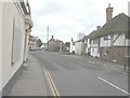
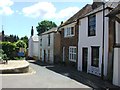
The Street, Ash
Taken from beside the fire-gutted former Lagaan restaurant with Image immediately on the right and the war memorial, situated at the junction with Moat Lane, further along.
Image: © John Baker
Taken: 30 Dec 2012
0.03 miles