IMAGES TAKEN NEAR TO
Mill Field, CANTERBURY, CT3 2BD
Introduction
This page details the photographs taken nearby to Mill Field, CT3 2BD by members of the Geograph project.
The Geograph project started in 2005 with the aim of publishing, organising and preserving representative images for every square kilometre of Great Britain, Ireland and the Isle of Man.

There are currently over 7.5m images from over14,400 individuals and you can help contribute to the project by visiting https://www.geograph.org.uk
Image Map
Images are licensed for reuse under creativecommons.org/licenses/by-sa/2.0
Notes
- Clicking on the map will re-center to the selected point.
- The higher the marker number, the further away the image location is from the centre of the postcode.
Image Listing (50 Images Found)
Images are licensed for reuse under creativecommons.org/licenses/by-sa/2.0
Image
Details
Distance
4
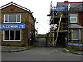
J R Cowan Ltd, 52, New Street
The business, which used to deal in electrical appliances as a retailer and supplier, is now permanently closed.
Image: © John Baker
Taken: 14 Aug 2020
0.05 miles
7
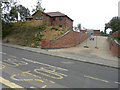
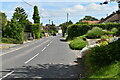
55, New Street
Planning permission was granted by Dover District Council under application number DOV/18/00878 for the “erection of detached dwelling, formation of new vehicular access, parking and associated landscaping”.
A similar view of Image after building work had been completed.
Image: © John Baker
Taken: 14 Aug 2020
0.07 miles