IMAGES TAKEN NEAR TO
Collar Makers Green, CANTERBURY, CT3 2BB
Introduction
This page details the photographs taken nearby to Collar Makers Green, CT3 2BB by members of the Geograph project.
The Geograph project started in 2005 with the aim of publishing, organising and preserving representative images for every square kilometre of Great Britain, Ireland and the Isle of Man.

There are currently over 7.5m images from over14,400 individuals and you can help contribute to the project by visiting https://www.geograph.org.uk
Image Map
Images are licensed for reuse under creativecommons.org/licenses/by-sa/2.0
Notes
- Clicking on the map will re-center to the selected point.
- The higher the marker number, the further away the image location is from the centre of the postcode.
Image Listing (40 Images Found)
Images are licensed for reuse under creativecommons.org/licenses/by-sa/2.0
Image
Details
Distance
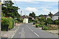
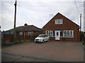
2
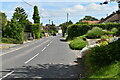
New Street, Ash
The section between Orchard View and Langdon Avenue.
Image: © John Baker
Taken: 30 Dec 2012
0.09 miles
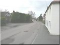
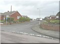
4
Looking W towards Ash from Saunders Lane
Image: © Nick Smith
Taken: 31 Jan 2009
0.10 miles
6
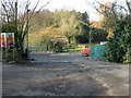
Entrance to Saunders Nursery on Saunders Lane
Image: © Nick Smith
Taken: 31 Jan 2009
0.11 miles
7
Orchard View, Ash
Seen from its junction with New Street.
Image: © John Baker
Taken: 30 Dec 2012
0.11 miles
8
New Street, Ash
Ahead, on the left, is a road sign indicating the turning into Image, whose entrance can be seen beyond it.
Image: © John Baker
Taken: 30 Dec 2012
0.12 miles
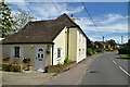
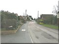
10
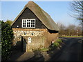
Thatched property on junction of Saunders Lane with Sandwich Road
Image: © Nick Smith
Taken: 31 Jan 2009
0.15 miles