IMAGES TAKEN NEAR TO
Gardners Close, CANTERBURY, CT3 2AG
Introduction
This page details the photographs taken nearby to Gardners Close, CT3 2AG by members of the Geograph project.
The Geograph project started in 2005 with the aim of publishing, organising and preserving representative images for every square kilometre of Great Britain, Ireland and the Isle of Man.

There are currently over 7.5m images from over14,400 individuals and you can help contribute to the project by visiting https://www.geograph.org.uk
Image Map
Images are licensed for reuse under creativecommons.org/licenses/by-sa/2.0
Notes
- Clicking on the map will re-center to the selected point.
- The higher the marker number, the further away the image location is from the centre of the postcode.
Image Listing (55 Images Found)
Images are licensed for reuse under creativecommons.org/licenses/by-sa/2.0
Image
Details
Distance
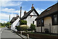
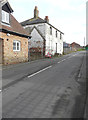
4
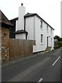
26, New Street
This was Image in February 2015, when it was in a derelict state. Since then, the house has been extensively renovated but, at present, is uninhabited.
Image: © John Baker
Taken: 14 Aug 2020
0.04 miles
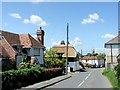
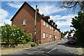
6
26, New Street
Still in the derelict state it was over two years ago when I was looking along Image
Image: © John Baker
Taken: 22 Feb 2015
0.04 miles
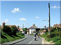
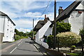
7
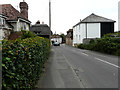
New Street, Ash
This was Image in December 2012, which shows the derelict state of number 26. Since then, number 26 (the nearest house on the right) has been extensively renovated but, at present, is uninhabited.
Image: © John Baker
Taken: 14 Aug 2020
0.04 miles