IMAGES TAKEN NEAR TO
Nargate Close, CANTERBURY, CT3 1UL
Introduction
This page details the photographs taken nearby to Nargate Close, CT3 1UL by members of the Geograph project.
The Geograph project started in 2005 with the aim of publishing, organising and preserving representative images for every square kilometre of Great Britain, Ireland and the Isle of Man.

There are currently over 7.5m images from over14,400 individuals and you can help contribute to the project by visiting https://www.geograph.org.uk
Image Map
Images are licensed for reuse under creativecommons.org/licenses/by-sa/2.0
Notes
- Clicking on the map will re-center to the selected point.
- The higher the marker number, the further away the image location is from the centre of the postcode.
Image Listing (100 Images Found)
Images are licensed for reuse under creativecommons.org/licenses/by-sa/2.0
Image
Details
Distance
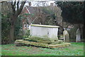
1
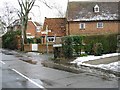
The former pub, The Basket Makers on Nargate Street
Image: © Nick Smith
Taken: 7 Dec 2007
0.03 miles
2
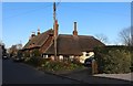
Thatched cottages on Nargate Street, Littlebourne
Image: © David Howard
Taken: 21 Mar 2020
0.03 miles
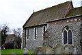
3
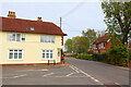
Nargate Street / Church Road
Road Junction in Littlebourne.
Image: © Wayland Smith
Taken: 2 May 2022
0.04 miles
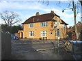
4
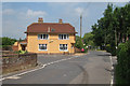
Orange House on Church Road
At junction with Nargate Street, the former The Basket Makers public house.
Image: © Oast House Archive
Taken: 24 Jun 2010
0.05 miles
5
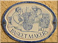
Plaque on the former pub of the same name
Image: © Nick Smith
Taken: 7 Dec 2007
0.05 miles
6
Former pub, The Basketmakers Arms
On Junction of Church Street and Nargate Street, Littlebourne
Image: © Nick Smith
Taken: 8 Feb 2007
0.05 miles
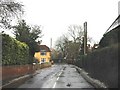
8
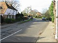
Looking NW along Church Road, Littlebourne
Image: © Nick Smith
Taken: 7 Dec 2007
0.06 miles