IMAGES TAKEN NEAR TO
The Hill, CANTERBURY, CT3 1TB
Introduction
This page details the photographs taken nearby to The Hill, CT3 1TB by members of the Geograph project.
The Geograph project started in 2005 with the aim of publishing, organising and preserving representative images for every square kilometre of Great Britain, Ireland and the Isle of Man.

There are currently over 7.5m images from over14,400 individuals and you can help contribute to the project by visiting https://www.geograph.org.uk
Image Map
Images are licensed for reuse under creativecommons.org/licenses/by-sa/2.0
Notes
- Clicking on the map will re-center to the selected point.
- The higher the marker number, the further away the image location is from the centre of the postcode.
Image Listing (43 Images Found)
Images are licensed for reuse under creativecommons.org/licenses/by-sa/2.0
Image
Details
Distance
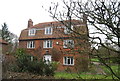
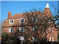
2
Old Oast, The Hill, Littlebourne
Image: © Oast House Archive
Taken: 19 May 2020
0.02 miles
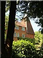
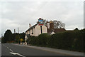
4
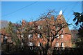
Old Oast, The Hill, Littlebourne
Image: © Oast House Archive
Taken: 27 Jan 2012
0.03 miles
5
Old Oast, The Hill, Littlebourne
Image: © Oast House Archive
Taken: 27 Jan 2012
0.03 miles
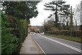

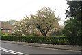
8
The Welcome Inns in Littlebourne (2)
The Evenhill at the top end of the village
Image: © David Long
Taken: 20 Apr 2006
0.04 miles

