IMAGES TAKEN NEAR TO
High Street, CANTERBURY, CT3 1SX
Introduction
This page details the photographs taken nearby to High Street, CT3 1SX by members of the Geograph project.
The Geograph project started in 2005 with the aim of publishing, organising and preserving representative images for every square kilometre of Great Britain, Ireland and the Isle of Man.

There are currently over 7.5m images from over14,400 individuals and you can help contribute to the project by visiting https://www.geograph.org.uk
Image Map
Images are licensed for reuse under creativecommons.org/licenses/by-sa/2.0
Notes
- Clicking on the map will re-center to the selected point.
- The higher the marker number, the further away the image location is from the centre of the postcode.
Image Listing (114 Images Found)
Images are licensed for reuse under creativecommons.org/licenses/by-sa/2.0
Image
Details
Distance
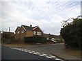
1
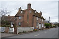
Dial Cottages
Grade II listed. https://www.britishlistedbuildings.co.uk/101085605-dial-cottages-littlebourne
Image: © N Chadwick
Taken: 13 Feb 2018
0.01 miles
3

Village gardens beside the High Street
A plaque, on railings near to the entrance to the children’s play park (to the left of these gardens) in Jubilee Road, mentions that “Viv Spratt and Littlebourne Youth Group is proud to give these Gardens to Littlebourne Parish Council on 17th April 2010. Funding for this project together with the BMX Track was achieved by grants obtained from Action with Rural Communities in Rural Kent, Canterbury City Council (and) Kent Playing Fields Association”
Image: © John Baker
Taken: 24 Sep 2013
0.01 miles
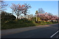
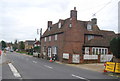
4
High Street, Littlebourne
Spring is finally here, the pink blossom has followed the daffodils coming out.
Image: © David Howard
Taken: 21 Mar 2020
0.01 miles
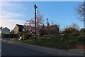
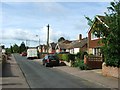
5
High Street (A257) in Littlebourne
Looking south-eastward.
Image: © Peter Wood
Taken: 16 Feb 2016
0.01 miles
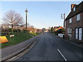
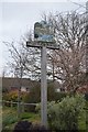
6
Rose Acre Road at the junction of The Hill
Image: © David Howard
Taken: 22 Jun 2017
0.01 miles
7
Dial Cottage
Grade II listed. http://www.britishlistedbuildings.co.uk/en-171304-dial-cottages-23-and-25-littlebourne
Image: © N Chadwick
Taken: 8 Jan 2012
0.01 miles
10
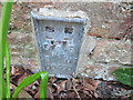
Ordnance Survey Flush Bracket S6455
This can be found on the wall of a house - private dwelling - in School Path, Littlebourne.
For more detail see : http://www.bench-marks.org.uk/bm19622
Image: © Peter Wood
Taken: 16 Feb 2016
0.03 miles