IMAGES TAKEN NEAR TO
High Street, CANTERBURY, CT3 1ST
Introduction
This page details the photographs taken nearby to High Street, CT3 1ST by members of the Geograph project.
The Geograph project started in 2005 with the aim of publishing, organising and preserving representative images for every square kilometre of Great Britain, Ireland and the Isle of Man.

There are currently over 7.5m images from over14,400 individuals and you can help contribute to the project by visiting https://www.geograph.org.uk
Image Map
Images are licensed for reuse under creativecommons.org/licenses/by-sa/2.0
Notes
- Clicking on the map will re-center to the selected point.
- The higher the marker number, the further away the image location is from the centre of the postcode.
Image Listing (122 Images Found)
Images are licensed for reuse under creativecommons.org/licenses/by-sa/2.0
Image
Details
Distance
1
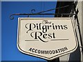
The Pilgrims Rest sign
Sign over a bed and breakfast in the centre of the village.
Image: © Oast House Archive
Taken: 27 Jan 2012
0.01 miles
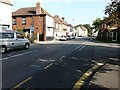
2
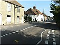
High Street
Seen from its junction with Orchard Close.
Image: © John Baker
Taken: 24 Sep 2013
0.02 miles
3
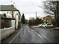
Looking N along Nargate Street, Littlebourne
Image: © Nick Smith
Taken: 8 Feb 2007
0.02 miles

6

Littlebourne Chapel
On Nargate Street.
Image: © David Anstiss
Taken: 15 Aug 2010
0.03 miles
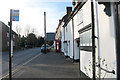
9
High Street
Seen from its junction with The Maltings.
Image: © John Baker
Taken: 24 Sep 2013
0.04 miles
10
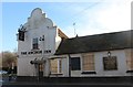
The Anchor Inn, Littlebourne
All boarded up and empty, it's anyone's guess what will happen to it next.
Image: © David Howard
Taken: 21 Mar 2020
0.04 miles