IMAGES TAKEN NEAR TO
Grove Road, CANTERBURY, CT3 1SE
Introduction
This page details the photographs taken nearby to Grove Road, CT3 1SE by members of the Geograph project.
The Geograph project started in 2005 with the aim of publishing, organising and preserving representative images for every square kilometre of Great Britain, Ireland and the Isle of Man.

There are currently over 7.5m images from over14,400 individuals and you can help contribute to the project by visiting https://www.geograph.org.uk
Image Map
Images are licensed for reuse under creativecommons.org/licenses/by-sa/2.0
Notes
- Clicking on the map will re-center to the selected point.
- The higher the marker number, the further away the image location is from the centre of the postcode.
Image Listing (6 Images Found)
Images are licensed for reuse under creativecommons.org/licenses/by-sa/2.0
Image
Details
Distance
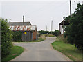
2
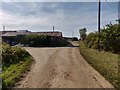
Supperton Farm
9 years on from the last photo. The open barn on the right has since burned down.
Image: © Nathan Barrow
Taken: 24 Aug 2019
0.04 miles
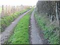
5
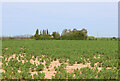
Field Near Stodmarsh
View from Green Lane.
Image: © Wayland Smith
Taken: 2 May 2022
0.21 miles
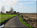
6
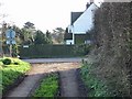
Junction of minor road with Grove Road at Frognall.
Image: © Nick Smith
Taken: 21 Jan 2007
0.22 miles