IMAGES TAKEN NEAR TO
Nargate Street, CANTERBURY, CT3 1QJ
Introduction
This page details the photographs taken nearby to Nargate Street, CT3 1QJ by members of the Geograph project.
The Geograph project started in 2005 with the aim of publishing, organising and preserving representative images for every square kilometre of Great Britain, Ireland and the Isle of Man.

There are currently over 7.5m images from over14,400 individuals and you can help contribute to the project by visiting https://www.geograph.org.uk
Image Map
Images are licensed for reuse under creativecommons.org/licenses/by-sa/2.0
Notes
- Clicking on the map will re-center to the selected point.
- The higher the marker number, the further away the image location is from the centre of the postcode.
Image Listing (65 Images Found)
Images are licensed for reuse under creativecommons.org/licenses/by-sa/2.0
Image
Details
Distance
7
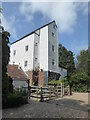
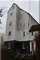
Littlebourne Mill, Nargate Street, Littlebourne
It is an 18th century Grade II listed building. The public footpath runs through the mill's grounds.
Image: © pam fray
Taken: 19 Aug 2018
0.03 miles
8
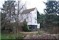
Littlebourne Mill
Grade II listed. http://www.britishlistedbuildings.co.uk/en-171327-littlebourne-mill-littlebourne
Image: © N Chadwick
Taken: 8 Jan 2012
0.03 miles
10
Littlebourne Mill
Grade II listed. https://www.britishlistedbuildings.co.uk/101372272-littlebourne-mill-littlebourne
Image: © N Chadwick
Taken: 13 Feb 2018
0.04 miles