IMAGES TAKEN NEAR TO
Bonnington, CANTERBURY, CT3 1PW
Introduction
This page details the photographs taken nearby to Bonnington, CT3 1PW by members of the Geograph project.
The Geograph project started in 2005 with the aim of publishing, organising and preserving representative images for every square kilometre of Great Britain, Ireland and the Isle of Man.

There are currently over 7.5m images from over14,400 individuals and you can help contribute to the project by visiting https://www.geograph.org.uk
Image Map
Images are licensed for reuse under creativecommons.org/licenses/by-sa/2.0
Notes
- Clicking on the map will re-center to the selected point.
- The higher the marker number, the further away the image location is from the centre of the postcode.
Image Listing (3 Images Found)
Images are licensed for reuse under creativecommons.org/licenses/by-sa/2.0
Image
Details
Distance
1
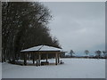
Pavilion near Nonington Court
Beside one of the many woods around the court and its farm buildings.
Image: © David Anstiss
Taken: 19 Dec 2010
0.07 miles
2
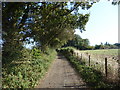
Cherrygarden Lane
Cherrygarden Lane leads from Station Road, between Goodnestone and Chillenden, to Sandwich Road at Nonington, near the Bruderhof Community at Beech Grove.
Image: © Marathon
Taken: 13 Sep 2020
0.13 miles
3
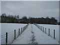
Footpath near Nonington Court
A path from Cherrygarden Lane (byway near Gooseberryhall Farm) leads around the Court towards Goodnestone.
The trees in the background is one of many small woods around the court and its farm buildings.
Image: © David Anstiss
Taken: 19 Dec 2010
0.22 miles