IMAGES TAKEN NEAR TO
The Street, CANTERBURY, CT3 1PL
Introduction
This page details the photographs taken nearby to The Street, CT3 1PL by members of the Geograph project.
The Geograph project started in 2005 with the aim of publishing, organising and preserving representative images for every square kilometre of Great Britain, Ireland and the Isle of Man.

There are currently over 7.5m images from over14,400 individuals and you can help contribute to the project by visiting https://www.geograph.org.uk
Image Map
Images are licensed for reuse under creativecommons.org/licenses/by-sa/2.0
Notes
- Clicking on the map will re-center to the selected point.
- The higher the marker number, the further away the image location is from the centre of the postcode.
Image Listing (261 Images Found)
Images are licensed for reuse under creativecommons.org/licenses/by-sa/2.0
Image
Details
Distance
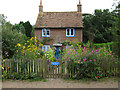
1
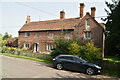
![Goodnestone houses [2]](https://s1.geograph.org.uk/geophotos/07/06/46/7064681_211de604_120x120.jpg)
Goodnestone houses [2]
Lindley House, The Street, was constructed in two phases in the early 19th century. Built of red brick under a tile roof. Listed, grade II, with details at: https://historicengland.org.uk/listing/the-list/list-entry/1363234
Goodnestone is a village adjacent to the Goodnestone House and Gardens estate, some 7 miles southeast of Canterbury. Many of the village houses were built by the estate.
Image: © Michael Dibb
Taken: 8 Sep 2021
0.00 miles
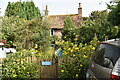
3
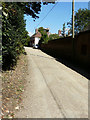
Looking northeast along The Street
In the direction of The Parsonage, where scaffolding has been erected around one of the chimney stacks. Vicarage Cottage is the house just beyond the car.
Image: © John Baker
Taken: 8 Sep 2016
0.01 miles
4
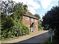
Vicarage Cottage, Goodnestone
A grade II listed building dated 1711.
Image: © Robin Webster
Taken: 2 Sep 2017
0.01 miles
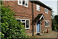
6
![Goodnestone houses [3]](https://s3.geograph.org.uk/geophotos/07/06/46/7064683_d9a1d239_120x120.jpg)
Goodnestone houses [3]
Vicarage Cottage, The Street, is dated 1711. Constructed of red brick under a tile roof. Listed, grade II, with details at: https://historicengland.org.uk/listing/the-list/list-entry/1099178
Goodnestone is a village adjacent to the Goodnestone House and Gardens estate, some 7 miles southeast of Canterbury. Many of the village houses were built by the estate.
Image: © Michael Dibb
Taken: 8 Sep 2021
0.01 miles
9
![Parish church [1]](https://s1.geograph.org.uk/geophotos/07/06/58/7065813_96975cce_120x120.jpg)
Parish church [1]
Steps leading from The Street to the churchyard.
The large Anglican parish church of the Holy Cross has 12th century origins. The north aisle is 14th century, the tower is 15th century and the nave and chancel were rebuilt and enlarged in 1839. Constructed of knapped flints, coursed in the 1839 section, with stone dressings, all under a tile roof. The internal fittings are mostly 19th century and there are some fine memorials. The church has recently undergone substantial interior renovation. Listed, grade I, with details at: https://historicengland.org.uk/listing/the-list/list-entry/1070258
Goodnestone is a village adjacent to the Goodnestone House and Gardens estate, some 7 miles southeast of Canterbury. Many of the village houses were built by the estate.
Image: © Michael Dibb
Taken: 8 Sep 2021
0.01 miles
10
![Goodnestone houses [1]](https://s3.geograph.org.uk/geophotos/07/06/46/7064679_6bcaa9a5_120x120.jpg)
Goodnestone houses [1]
Almost hidden behind the foliage is West House Cottage, The Street. Built in the 18th century in red brick under a plain tile roof. Listed, grade II, with details at: https://historicengland.org.uk/listing/the-list/list-entry/1070264
Goodnestone is a village adjacent to the Goodnestone House and Gardens estate, some 7 miles southeast of Canterbury. Many of the village houses were built by the estate.
Image: © Michael Dibb
Taken: 8 Sep 2021
0.02 miles