IMAGES TAKEN NEAR TO
Boyes Lane, CANTERBURY, CT3 1PD
Introduction
This page details the photographs taken nearby to Boyes Lane, CT3 1PD by members of the Geograph project.
The Geograph project started in 2005 with the aim of publishing, organising and preserving representative images for every square kilometre of Great Britain, Ireland and the Isle of Man.

There are currently over 7.5m images from over14,400 individuals and you can help contribute to the project by visiting https://www.geograph.org.uk
Image Map
Images are licensed for reuse under creativecommons.org/licenses/by-sa/2.0
Notes
- Clicking on the map will re-center to the selected point.
- The higher the marker number, the further away the image location is from the centre of the postcode.
Image Listing (65 Images Found)
Images are licensed for reuse under creativecommons.org/licenses/by-sa/2.0
Image
Details
Distance
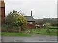
1
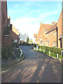
Fitzwalters Meadow
A recently completed close of houses, seen from Boyes Lane
Image: © John Baker
Taken: 14 Jan 2015
0.05 miles
2
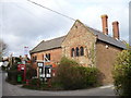
Goodnestone post office
How much longer will this village post office survive? There is a building site behind it for several new houses.
Image: © pam fray
Taken: 25 Jan 2008
0.07 miles
3
![Goodnestone houses [18]](https://s0.geograph.org.uk/geophotos/07/06/57/7065796_c8376c47_120x120.jpg)
Goodnestone houses [18]
Hop View, Saddler's Hill, is a late 17th century house. Built of red brick under a thatch roof. Listed, grade II, with details at: https://historicengland.org.uk/listing/the-list/list-entry/1070294
Goodnestone is a village adjacent to the Goodnestone House and Gardens estate, some 7 miles southeast of Canterbury. Many of the village houses were built by the estate.
Image: © Michael Dibb
Taken: 8 Sep 2021
0.07 miles
5
Hop Cottage, Saddlers Hill
Planning permission has been granted by Dover District Council under application number DOV/20/00244 for the “erection of a detached dwelling with integral garage, associated parking and landscaping and relocation of oil tank (3 outbuildings to be demolished) (amended plans)".
Image: © John Baker
Taken: 14 Aug 2020
0.08 miles
6
View from Boyes Lane at junction with Cave Lane
Goodnestone.
Image: © Nick Smith
Taken: 3 Jan 2007
0.08 miles
7
![Goodnestone houses [16]](https://s2.geograph.org.uk/geophotos/07/06/57/7065790_7c8b7233_120x120.jpg)
Goodnestone houses [16]
Ivy House, Saddler's Hill, was built in the 18th century and altered in the 19th century. Constructed of red brick under a tile roof. Listed, grade II, with details at: https://historicengland.org.uk/listing/the-list/list-entry/1363212
Goodnestone is a village adjacent to the Goodnestone House and Gardens estate, some 7 miles southeast of Canterbury. Many of the village houses were built by the estate.
Image: © Michael Dibb
Taken: 8 Sep 2021
0.09 miles
8
![Goodnestone features [2]](https://s0.geograph.org.uk/geophotos/07/06/57/7065792_b26e6273_120x120.jpg)
Goodnestone features [2]
Hidden amongst the foliage on Saddler's Hill is this gate with two coats of arms on the overthrow. The building in the background is North Lodge.
Goodnestone is a village adjacent to the Goodnestone House and Gardens estate, some 7 miles southeast of Canterbury. Many of the village houses were built by the estate.
Image: © Michael Dibb
Taken: 8 Sep 2021
0.09 miles
9
![Goodnestone houses [15]](https://s1.geograph.org.uk/geophotos/07/06/57/7065789_3531ce81_120x120.jpg)
Goodnestone houses [15]
Yew Tree Farmhouse, Saddler's Hill, was built in the early 19th century. Constructed of red brick under a tile roof. Listed, grade II, with details at: https://historicengland.org.uk/listing/the-list/list-entry/1336991
Goodnestone is a village adjacent to the Goodnestone House and Gardens estate, some 7 miles southeast of Canterbury. Many of the village houses were built by the estate.
Image: © Michael Dibb
Taken: 8 Sep 2021
0.09 miles
10
![Goodnestone houses [17]](https://s3.geograph.org.uk/geophotos/07/06/57/7065795_ef48d5cb_120x120.jpg)
Goodnestone houses [17]
Numbers 1 and 2 North Corner Cottages, Saddler's Hill, are a pair of timber framed cottages, encased in brick in 1778. The casing is of red brick and of red and blue brick in a diaper pattern, all under a tile roof. Listed, grade II, with details at: https://historicengland.org.uk/listing/the-list/list-entry/1336988
Goodnestone is a village adjacent to the Goodnestone House and Gardens estate, some 7 miles southeast of Canterbury. Many of the village houses were built by the estate.
Image: © Michael Dibb
Taken: 8 Sep 2021
0.09 miles