IMAGES TAKEN NEAR TO
Bramling, CANTERBURY, CT3 1LY
Introduction
This page details the photographs taken nearby to CT3 1LY by members of the Geograph project.
The Geograph project started in 2005 with the aim of publishing, organising and preserving representative images for every square kilometre of Great Britain, Ireland and the Isle of Man.

There are currently over 7.5m images from over14,400 individuals and you can help contribute to the project by visiting https://www.geograph.org.uk
Image Map
Images are licensed for reuse under creativecommons.org/licenses/by-sa/2.0
Notes
- Clicking on the map will re-center to the selected point.
- The higher the marker number, the further away the image location is from the centre of the postcode.
Image Listing (20 Images Found)
Images are licensed for reuse under creativecommons.org/licenses/by-sa/2.0
Image
Details
Distance
1
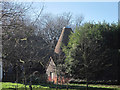
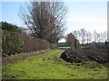
Oast House at Duckpits Farmhouse, Ickham And Well
Image: © Oast House Archive
Taken: 27 Jan 2012
0.01 miles
2
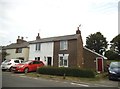
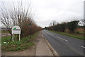
Cottages on Wingham Road
Between Littlebourne and Bramling
Image: © David Howard
Taken: 22 Jun 2017
0.10 miles
4
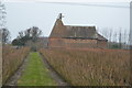
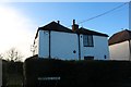
April Cottage
Grade II listed https://historicengland.org.uk/listing/the-list/list-entry/1085611 cottage at the corner of High Street and Cherville Lane.
Image: © Oast House Archive
Taken: 27 Jan 2012
0.11 miles
5
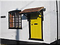
April Cottage entrance
Grade II listed https://historicengland.org.uk/listing/the-list/list-entry/1085611 cottage at the corner of High Street and Cherville Lane.
Also see Image
Image: © Oast House Archive
Taken: 27 Jan 2012
0.11 miles
6
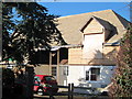
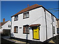
Rose Cottage
A second storey is being added to this bungalow.
Image: © Oast House Archive
Taken: 27 Jan 2012
0.14 miles