IMAGES TAKEN NEAR TO
Preston Meadows, CANTERBURY, CT3 1FU
Introduction
This page details the photographs taken nearby to Preston Meadows, CT3 1FU by members of the Geograph project.
The Geograph project started in 2005 with the aim of publishing, organising and preserving representative images for every square kilometre of Great Britain, Ireland and the Isle of Man.

There are currently over 7.5m images from over14,400 individuals and you can help contribute to the project by visiting https://www.geograph.org.uk
Image Map
Images are licensed for reuse under creativecommons.org/licenses/by-sa/2.0
Notes
- Clicking on the map will re-center to the selected point.
- The higher the marker number, the further away the image location is from the centre of the postcode.
Image Listing (22 Images Found)
Images are licensed for reuse under creativecommons.org/licenses/by-sa/2.0
Image
Details
Distance
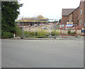
1
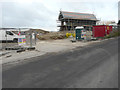
Preston Grange, Grove Road
Planning permission has been granted by Dover District Council under application number DOV/14/00842 for an “outline application for the erection of 73 residential dwellings and related infrastructure, together with the creation of meadow-land (existing buildings to be demolished) (all matters reserved) “.
The houses are being constructed on this Image, which used to occupied by the haulage firm A Salvatori & Son Ltd, The site extends as far as Image, which is nearer the village centre. Preston Grange is the name, which has been given to the development.
Image: © John Baker
Taken: 2 Jan 2019
0.05 miles
2
Preston Grange, Grove Road
Planning permission has been granted by Dover District Council under application number DOV/14/00842 for an “outline application for the erection of 73 residential dwellings and related infrastructure, together with the creation of meadow-land (existing buildings to be demolished) (all matters reserved) “.
This was the same house at Image in January 2019. Preston Grange is the name, which has been given to the development.
Image: © John Baker
Taken: 10 Mar 2020
0.05 miles
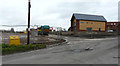
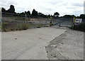
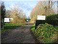
3
Derelict site, Grove Road
The site was once the premises of the haulage firm A Salvatori & Son Ltd http://www.salvatori.com/index.html which has now moved to Aylesham Industrial Estate in Image
Image: © John Baker
Taken: 17 Aug 2016
0.07 miles
4
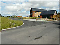
Preston Grange, Grove Road
This was the same house at Image before its construction has been completed. Preston Grange is the name, which has been given to the development.
Image: © John Baker
Taken: 9 Aug 2021
0.07 miles
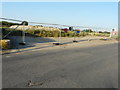
5
Derelict site, Grove Road
It was used to store the trailers of the haulage firm A Salvatori & Son Ltd http://www.salvatori.com/index.html which has now moved to Aylesham Industrial Estate in Image The firm’s former site is also a Image
Image: © John Baker
Taken: 21 Aug 2016
0.10 miles
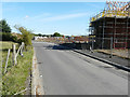
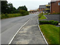
6
Grove Road
Here, the road goes past Preston Grange, which is the name of a housing development under construction.
Planning permission was granted by Dover District Council under application number DOV/14/00842 for an “outline application for the erection of 73 residential dwellings and related infrastructure, together with the creation of meadow-land (existing buildings to be demolished) (all matters reserved). The location was described as land at Salvatori, north and south of Grove Road.
Image: © John Baker
Taken: 10 Jun 2018
0.10 miles
7
Preston Grange, Grove Road
Planning permission was granted by Dover District Council under application number DOV/14/00842 for an “outline application for the erection of 73 residential dwellings and related infrastructure, together with the creation of meadow-land (existing buildings to be demolished) (all matters reserved). The location was described as land at Salvatori, north and south of Grove Road.
Image: © John Baker
Taken: 10 Sep 2017
0.12 miles
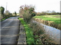
10
Grove Road
Here, the road goes past Preston Grange, which is the name of a housing development under construction.
Planning permission was granted by Dover District Council under application number DOV/14/00842 for an “outline application for the erection of 73 residential dwellings and related infrastructure, together with the creation of meadow-land (existing buildings to be demolished) (all matters reserved). The location was described as land at Salvatori, north and south of Grove Road.
Image: © John Baker
Taken: 10 Jun 2018
0.14 miles