IMAGES TAKEN NEAR TO
Walmestone, CANTERBURY, CT3 1ES
Introduction
This page details the photographs taken nearby to Walmestone, CT3 1ES by members of the Geograph project.
The Geograph project started in 2005 with the aim of publishing, organising and preserving representative images for every square kilometre of Great Britain, Ireland and the Isle of Man.

There are currently over 7.5m images from over14,400 individuals and you can help contribute to the project by visiting https://www.geograph.org.uk
Image Map
Images are licensed for reuse under creativecommons.org/licenses/by-sa/2.0
Notes
- Clicking on the map will re-center to the selected point.
- The higher the marker number, the further away the image location is from the centre of the postcode.
Image Listing (43 Images Found)
Images are licensed for reuse under creativecommons.org/licenses/by-sa/2.0
Image
Details
Distance
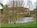
2
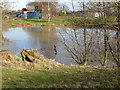
Pond at Little Walmestone
Frozen in parts, the ducks swam and walked across it.
Image: © Nick Smith
Taken: 14 Feb 2009
0.04 miles
5
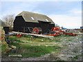
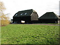
Barn and farm machinery, Little Walmestone.
Image: © Nick Smith
Taken: 21 Jan 2007
0.06 miles
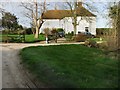
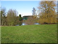
7
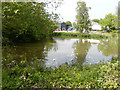
Pond, Walmestone Court Farm, Walmestone Road
The same Image but from a different angle and a contrast to the weather conditions prevailing at the time when I took this image.
Image: © John Baker
Taken: 20 May 2018
0.06 miles
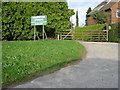
8
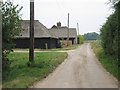
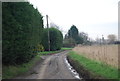
Barn at Walmestone Court Farm
Looking along Walmestone Road.
Image: © Oast House Archive
Taken: 20 Jul 2010
0.07 miles