IMAGES TAKEN NEAR TO
Wenderton Lane, CANTERBURY, CT3 1EN
Introduction
This page details the photographs taken nearby to Wenderton Lane, CT3 1EN by members of the Geograph project.
The Geograph project started in 2005 with the aim of publishing, organising and preserving representative images for every square kilometre of Great Britain, Ireland and the Isle of Man.

There are currently over 7.5m images from over14,400 individuals and you can help contribute to the project by visiting https://www.geograph.org.uk
Image Map
Images are licensed for reuse under creativecommons.org/licenses/by-sa/2.0
Notes
- Clicking on the map will re-center to the selected point.
- The higher the marker number, the further away the image location is from the centre of the postcode.
Image Listing (10 Images Found)
Images are licensed for reuse under creativecommons.org/licenses/by-sa/2.0
Image
Details
Distance
1
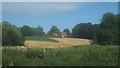
Wood Cottage
As seen from River Little Stour. On the left is Wenderton Hoath (wood). Hanging Bank Wood is on the right.
Image: © David Anstiss
Taken: 11 Jul 2010
0.01 miles
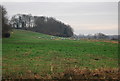
3
View from the River Little Stour
Looking south-easterly towards Wingham. Between Wenderton Hoath (wood on the left) and Myles Garden (wood on the right).
The spire of St. Mary's Church is seen in the far background.
Image: © David Anstiss
Taken: 11 Jul 2010
0.19 miles
4
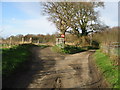
Junction in road
The left hand lane is private.
Image: © Nick Smith
Taken: 21 Jan 2007
0.20 miles
5

Wenderton Lane, north of Wingham
Next to Wenderton Hoath.
Image: © pam fray
Taken: 17 Jan 2022
0.23 miles
6
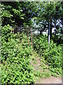
Footpath to Deadmill Bridge
A rather large iron kissing gate prevents anything but pedestrians using the path.
Image: © Nick Smith
Taken: 15 Jun 2008
0.24 miles
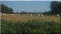
7
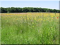
View across flower filled meadow to Wenderton Hoath
Image: © Nick Smith
Taken: 15 Jun 2008
0.24 miles
8
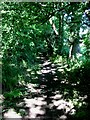
Footpath to Deadmill Bridge
The path passes along the edge of Wenderton Hoath, the woodland is full of bluebells during late spring.
Image: © Nick Smith
Taken: 15 Jun 2008
0.24 miles
10
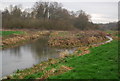
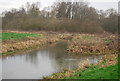
Confluence of the Little Stour and Wingham River
Image: © N Chadwick
Taken: 12 Jan 2013
0.25 miles