IMAGES TAKEN NEAR TO
The Street, CANTERBURY, CT3 1EB
Introduction
This page details the photographs taken nearby to The Street, CT3 1EB by members of the Geograph project.
The Geograph project started in 2005 with the aim of publishing, organising and preserving representative images for every square kilometre of Great Britain, Ireland and the Isle of Man.

There are currently over 7.5m images from over14,400 individuals and you can help contribute to the project by visiting https://www.geograph.org.uk
Image Map
Images are licensed for reuse under creativecommons.org/licenses/by-sa/2.0
Notes
- Clicking on the map will re-center to the selected point.
- The higher the marker number, the further away the image location is from the centre of the postcode.
Image Listing (70 Images Found)
Images are licensed for reuse under creativecommons.org/licenses/by-sa/2.0
Image
Details
Distance
1

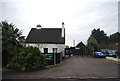
The Half Moon and Seven Stars
Grade II listed. http://www.britishlistedbuildings.co.uk/en-178246-half-moon-and-seven-stars-preston-kent
Image: © N Chadwick
Taken: 12 Jan 2013
0.02 miles
5
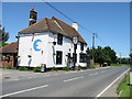
The Half Moon and Seven Stars pub, Preston
Image: © Nick Smith
Taken: 15 Jun 2008
0.04 miles
9
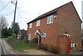
The Old Telephone Exchange
Now converted to a private residence.
Image: © N Chadwick
Taken: 12 Jan 2013
0.05 miles
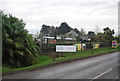
10
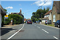
The Street, Preston
Heading north towards Stourmouth.
Image: © Robin Webster
Taken: 15 Jun 2019
0.05 miles