IMAGES TAKEN NEAR TO
The Downs, CANTERBURY, CT3 1DX
Introduction
This page details the photographs taken nearby to The Downs, CT3 1DX by members of the Geograph project.
The Geograph project started in 2005 with the aim of publishing, organising and preserving representative images for every square kilometre of Great Britain, Ireland and the Isle of Man.

There are currently over 7.5m images from over14,400 individuals and you can help contribute to the project by visiting https://www.geograph.org.uk
Image Map
Images are licensed for reuse under creativecommons.org/licenses/by-sa/2.0
Notes
- Clicking on the map will re-center to the selected point.
- The higher the marker number, the further away the image location is from the centre of the postcode.
Image Listing (65 Images Found)
Images are licensed for reuse under creativecommons.org/licenses/by-sa/2.0
Image
Details
Distance
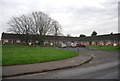
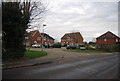
3
The Street, Preston
Heading north towards Stourmouth.
Image: © Robin Webster
Taken: 15 Jun 2019
0.03 miles
4
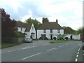
The Street, Preston. Mill Lane on left between houses
Image: © Paul Hensman
Taken: 9 May 2005
0.03 miles
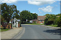
5
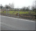
Development land, The Street
Planning permission has been granted by Dover District Council under application number DOV/17/00010 for the “erection of a detached dwelling and garage and creation of associated parking”. The land belongs to 1, Luckett Cottages, but the house is out of shot to the left.
Image: © John Baker
Taken: 6 Jan 2019
0.04 miles
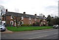
6
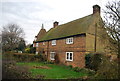
Luckett Cottages
Grade II listed. http://www.britishlistedbuildings.co.uk/en-178241-luckett-cottages-preston-kent
Image: © N Chadwick
Taken: 12 Jan 2013
0.05 miles
10
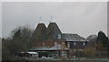
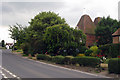
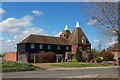
View of Lucketts Farm Oast
Rear view of the farm oast, as seen from the footpath towards Preston.
Image: © David Anstiss
Taken: 29 Nov 2010
0.05 miles