IMAGES TAKEN NEAR TO
Park Lane, CANTERBURY, CT3 1DS
Introduction
This page details the photographs taken nearby to Park Lane, CT3 1DS by members of the Geograph project.
The Geograph project started in 2005 with the aim of publishing, organising and preserving representative images for every square kilometre of Great Britain, Ireland and the Isle of Man.

There are currently over 7.5m images from over14,400 individuals and you can help contribute to the project by visiting https://www.geograph.org.uk
Image Map
Images are licensed for reuse under creativecommons.org/licenses/by-sa/2.0
Notes
- Clicking on the map will re-center to the selected point.
- The higher the marker number, the further away the image location is from the centre of the postcode.
Image Listing (57 Images Found)
Images are licensed for reuse under creativecommons.org/licenses/by-sa/2.0
Image
Details
Distance
6
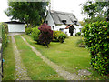
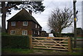
Lockesley, The Forstal
The house as viewed across the garden, while this image of Image was viewed from the road.
Image: © John Baker
Taken: 10 Jun 2018
0.06 miles
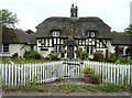
7
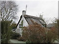
Thatched cottage on The Forstal, Preston
This cottage, with a frozen thatched roof, is called Lockesley.
Image: © David Anstiss
Taken: 29 Nov 2010
0.06 miles
8
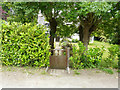
Lockesley, The Forstal
The name of the house is affixed to the gate.
Image: © John Baker
Taken: 10 Jun 2018
0.06 miles
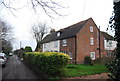
9
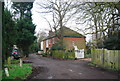
Forstal Farmhouse
Grade II listed. http://www.britishlistedbuildings.co.uk/en-178217-forstal-farmhouse-preston-kent
Image: © N Chadwick
Taken: 12 Jan 2013
0.07 miles