IMAGES TAKEN NEAR TO
Palmer Road, CANTERBURY, CT3 1BS
Introduction
This page details the photographs taken nearby to Palmer Road, CT3 1BS by members of the Geograph project.
The Geograph project started in 2005 with the aim of publishing, organising and preserving representative images for every square kilometre of Great Britain, Ireland and the Isle of Man.

There are currently over 7.5m images from over14,400 individuals and you can help contribute to the project by visiting https://www.geograph.org.uk
Image Map
Images are licensed for reuse under creativecommons.org/licenses/by-sa/2.0
Notes
- Clicking on the map will re-center to the selected point.
- The higher the marker number, the further away the image location is from the centre of the postcode.
Image Listing (217 Images Found)
Images are licensed for reuse under creativecommons.org/licenses/by-sa/2.0
Image
Details
Distance
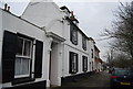
4
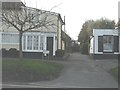
The entrance to New Town, Wingham
Seen from across the High Street.
Image: © John Baker
Taken: 31 Jan 2013
0.03 miles
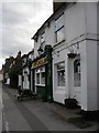
6
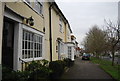
45, High St
Grade II listed. http://www.britishlistedbuildings.co.uk/en-178325-45-high-street-wingham-kent
Image: © N Chadwick
Taken: 12 Jan 2013
0.04 miles
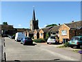
8
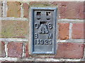
Ordnance Survey Flush Bracket 11929
This can be found on the wall of a house - private dwelling - in High Street, Wingham.
For more detail see : http://www.bench-marks.org.uk/bm22658
Image: © Peter Wood
Taken: 16 Feb 2016
0.04 miles
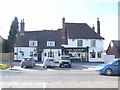
9
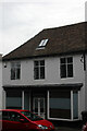
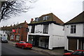
44 High Street, Wingham
Grade II Listed house dated 1620. A 2017 paper by E W Parkin, Kent Archaeological Society, describes the now restaurant as 'once a symmetrical eighteenth century house of two storeys'. He also describes the date painted in the heart shaped stone as 1720 but in my photo and as far back as 2009 it clearly said 1620. He also dates the shop front as Victorian. In Google street view from 2009 (when it carried sale boards) to 2019 there is no evidence of it having been a restaurant. The 1987 listing also describes it as a restaurant so I suspect Parkin's text is from an earlier document. From before 2000 it was 'The Tanner of Wingham' restaurant and B&B whose website reported it had moved before September 2004. It appears to have been two flats from at least 2016 but I'm unable to find a change of use planning application.
Image: © Jo and Steve Turner
Taken: 8 Jul 2016
0.04 miles