IMAGES TAKEN NEAR TO
North Court Road, CANTERBURY, CT3 1BN
Introduction
This page details the photographs taken nearby to North Court Road, CT3 1BN by members of the Geograph project.
The Geograph project started in 2005 with the aim of publishing, organising and preserving representative images for every square kilometre of Great Britain, Ireland and the Isle of Man.

There are currently over 7.5m images from over14,400 individuals and you can help contribute to the project by visiting https://www.geograph.org.uk
Image Map
Images are licensed for reuse under creativecommons.org/licenses/by-sa/2.0
Notes
- Clicking on the map will re-center to the selected point.
- The higher the marker number, the further away the image location is from the centre of the postcode.
Image Listing (208 Images Found)
Images are licensed for reuse under creativecommons.org/licenses/by-sa/2.0
Image
Details
Distance
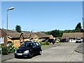
1
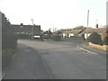
North Court Close, Wingham
Seen from North Court Road. The bungalows along North Court Road (round the corner) are of a similar design to those in North Court Close.
Image: © John Baker
Taken: 31 Jan 2013
0.01 miles
2
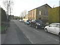
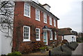
Toomer House & Little Toomer, North Court Road
Planning permission has been granted by Dover District Council under application number DOV/09/0064 for the “change of use and conversion to 2 residential dwellings, construction of vehicular access and associated car parking”. The larger part of the building is Toomer House which dates from 1836 (this is inscribed in the brickwork, above the three windows to the left of the hedge).
Image: © John Baker
Taken: 31 Jan 2013
0.02 miles
3
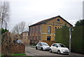
Toomer House
This building is now a private residence, but was built as an Independent Chapel by the Rev. Samuel Elgar Toomer (1787-1870) in 1835. It was renovated in 1885 at a cost of £400 with seating for 300 people. In 1897 it was listed as the Congregational Chapel. The Chapel is believed to have been used as a Drill Hall sometime between 1899-1902 by the 1st Volunteer (Militia) Battalion of the Buffs (Royal East Kent) Regiment prior to deployment in the Boer War.
Image: © N Chadwick
Taken: 12 Jan 2013
0.03 miles
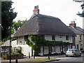
5
The Old Manse
Grade II listed. http://www.britishlistedbuildings.co.uk/en-178343-the-old-manse-wingham-kent
Image: © N Chadwick
Taken: 12 Jan 2013
0.04 miles
6
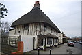
The Old Ship
Grade II listed. http://www.britishlistedbuildings.co.uk/en-178345-the-old-ship-wingham-kent
Image: © N Chadwick
Taken: 12 Jan 2013
0.04 miles
7
The Old Ship, High Street, Wingham, Kent
Grade II listed.
Image: © Oast House Archive
Taken: 4 Jul 2009
0.04 miles
8
The Old Ship, High Street, Wingham
Grade II Listed house from about 1600. The Ship Inn supposedly opened in 1914 but shows up in the 1881 census. Further investigation shows Melville's 1858 Kent directory contains the entry 'Phillips, Henry, beer retailer, Ship'. A Ship is not listed in Bagshaw's 1847 directory so presumably the pub was established between 1847 and 1858. It was converted into a house around 1975 and spent some time as a shop. It was extensively refurbished in 2005/2006 and is currently (2016) a B&B. The listed landlords include; 1891 Charles Phillips, H Champ 1914-1941, T Hogben 1941 on and John Waterman in 1974.
Image: © Jo and Steve Turner
Taken: 8 Jul 2016
0.04 miles
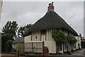
10
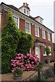
The Old Manse, High Street, Wingham
A fine Georgian façade dated 1722 hiding an earlier 16th/17th Century Grade II Listed house.
Image: © Jo and Steve Turner
Taken: 8 Jul 2016
0.05 miles