IMAGES TAKEN NEAR TO
High Street, CANTERBURY, CT3 1BL
Introduction
This page details the photographs taken nearby to High Street, CT3 1BL by members of the Geograph project.
The Geograph project started in 2005 with the aim of publishing, organising and preserving representative images for every square kilometre of Great Britain, Ireland and the Isle of Man.

There are currently over 7.5m images from over14,400 individuals and you can help contribute to the project by visiting https://www.geograph.org.uk
Image Map
Images are licensed for reuse under creativecommons.org/licenses/by-sa/2.0
Notes
- Clicking on the map will re-center to the selected point.
- The higher the marker number, the further away the image location is from the centre of the postcode.
Image Listing (217 Images Found)
Images are licensed for reuse under creativecommons.org/licenses/by-sa/2.0
Image
Details
Distance
4
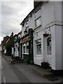
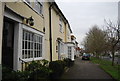
The entrance to New Town, Wingham
Seen from across the High Street.
Image: © John Baker
Taken: 31 Jan 2013
0.03 miles
6
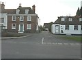
The entrance to Sweetlove Place
Seen from across the High Street.
Image: © John Baker
Taken: 31 Jan 2013
0.04 miles
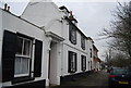
9
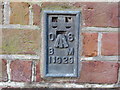
Ordnance Survey Flush Bracket 11929
This can be found on the wall of a house - private dwelling - in High Street, Wingham.
For more detail see : http://www.bench-marks.org.uk/bm22658
Image: © Peter Wood
Taken: 16 Feb 2016
0.04 miles
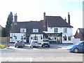
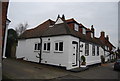
10
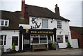
The Anchor Inn
Grade II listed. http://www.britishlistedbuildings.co.uk/en-178346-the-anchor-inn-and-rear-courtyard-wingha
Image: © N Chadwick
Taken: 12 Jan 2013
0.04 miles